Victoria river levels
Are the rivers and lakes in Victoria unusually low or high?
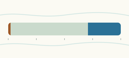
We follow 292 water level gauges in Victoria. By their latest daily means, 27 gauges read below their normal range for the date and 9 gauges above it.
How many gauges do we follow in Victoria?
292 gauges of the 640 we follow in Australia, as of 11 November 2026.
How many waters in Victoria have a level gauge?
168 waters with a level gauge, of the 398 waters we follow in Australia, as of 11 November 2026.
How many gauges read below normal for the date?
27 gauges below their normal range, of the 271 gauges with a latest daily mean and a normal range for its date, as of 11 November 2026 at the latest.
How many gauges read above normal for the date?
9 gauges above their normal range, of the 271 gauges with a latest daily mean and a normal range for its date, as of 11 November 2026 at the latest.
How the places stand at their latest reading
27 places below normal and 9 places above
Which gauges do we follow in Victoria?
| Place | Reading | Against normal for the date | Change in a day |
|---|---|---|---|
| Acheron River | |||
| Taggerty | 0.809 m | within the normal range for the date | -0.014 m |
| Agnes River | |||
| Toora | 0.311 m | within the normal range for the date | -0.004 m |
| Aire River | |||
| Wyelangta | 0.406 m | in the lowest 10 percent for the date | -0.005 m |
| Avoca River | |||
| Amphitheatre | 0.334 m | within the normal range for the date | -0.003 m |
| Archdale Junction | 0.341 m | within the normal range for the date | -0.004 m |
| Charlton | 0.965 m | -0.021 m | |
| Quambatook | 0.571 m | within the normal range for the date | -0.029 m |
| Sandhill Lake Road | 77.154 m | within the normal range for the date | -0.002 m |
| Avon River (Thomson) | |||
| The Channel | 1.52 m | within the normal range for the date | +0.021 m |
| Avon River (Wimmera Avon) | |||
| Wimmera Highway | 0.962 m | within the normal range for the date | -0.003 m |
| Axe Creek | |||
| Longlea | 0.387 m | within the normal range for the date | 0 m |
| Strathfieldsaye | 1.287 m | within the normal range for the date | -0.009 m |
| Barringo Creek | |||
| Barringo (Upstream of Diversion) | 0.239 m | within the normal range for the date | -0.002 m |
| Barwon River | |||
| Inverleigh | 0.434 m | within the normal range for the date | -0.056 m |
| Kildean Lane | 0.99 m | within the normal range for the date | -0.042 m |
| Pollocksford | 0.603 m | within the normal range for the date | -0.008 m |
| Ricketts Marsh | 0.431 m | within the normal range for the date | -0.004 m |
| Winchelsea | 0.666 m | within the normal range for the date | -0.012 m |
| Bemm River | |||
| Princes Highway | 1.463 m | in the lowest 10 percent for the date | -0.005 m |
| Bendigo Creek | |||
| Bendigo | 1.143 m | within the normal range for the date | -0.001 m |
| Huntly | 0.268 m | within the normal range for the date | -0.001 m |
| Minto | 0.829 m | in the highest 10 percent for the date | +0.115 m |
| Bet Bet Creek | |||
| Bet Bet | 1.32 m | within the normal range for the date | -0.006 m |
| Lillicur | 1.226 m | within the normal range for the date | -0.01 m |
| Norwood | 0.253 m | within the normal range for the date | -0.001 m |
| Big River (Goulburn) | |||
| Jamieson | 0.606 m | within the normal range for the date | -0.008 m |
| Big River (Upper Murray) | |||
| Jokers Creek | 0.998 m | in the lowest 10 percent for the date | -0.006 m |
| Birch Creek (Victoria) | |||
| Smeaton | 0.703 m | within the normal range for the date | +0.007 m |
| Birregurra Creek | |||
| Ricketts Marsh | 0.119 m | within the normal range for the date | -0.001 m |
| Boggy Creek (Victoria) | |||
| Angleside | 0.138 m | in the lowest 5 percent for the date | -0.002 m |
| Boosey Creek | |||
| Tungamah | 0.191 m | in the lowest 5 percent for the date | +0.004 m |
| Boundary Creek (Victoria) | |||
| Yeodene | 0.177 m | within the normal range for the date | +0.014 m |
| Box Creek | |||
| Mansfield's Bridge | 78.583 m | within the normal range for the date | +0.009 m |
| Brankeet Creek | |||
| Ancona | 0.144 m | within the normal range for the date | -0.002 m |
| Brodribb River | |||
| Sardine Creek | 0.519 m | within the normal range for the date | -0.003 m |
| Broken Creek | |||
| Katamatite | 0.973 m | within the normal range for the date | -0.005 m |
| Waggarandall Weir | 0.514 m | ||
| Broken River (Victoria) | |||
| Downstream of Back Creek Junction | 1.14 m | within the normal range for the date | +0.016 m |
| Goorambat (Casey Weir Head Gauge) | 0.41 m | within the normal range for the date | +0.003 m |
| Gowangardie | 0.645 m | within the normal range for the date | +0.025 m |
| Orrvale | 1.384 m | within the normal range for the date | +0.02 m |
| Bruthen Creek | |||
| Carrajung Lower | 0.80 m | within the normal range for the date | -0.007 m |
| Buchan River | |||
| Buchan | 1.016 m | in the lowest 5 percent for the date | -0.01 m |
| Buckland River | |||
| Harris Lane | 1.389 m | within the normal range for the date | -0.004 m |
| Twelve Mile | 1.321 m | within the normal range for the date | -0.004 m |
| Buffalo River (Victoria) | |||
| Abbeyard | 0.658 m | within the normal range for the date | -0.011 m |
| Lake Buffalo | 0.644 m | within the normal range for the date | 0 m |
| Bullock Creek | |||
| East Loddon | 0.536 m | within the normal range for the date | -0.004 m |
| Marong | 0.978 m | within the normal range for the date | -0.007 m |
| Burrumbeet Creek | |||
| Lake Burrumbeet | 1.234 m | within the normal range for the date | -0.002 m |
| Campaspe River | |||
| Ashbourne | 0.232 m | within the normal range for the date | -0.043 m |
| Barnadown | 1.474 m | ||
| Eppalock | 153.423 m | within the normal range for the date | -0.001 m |
| Fehrings Lane | 1.553 m | within the normal range for the date | +0.002 m |
| Redesdale | 0.828 m | within the normal range for the date | -0.008 m |
| Rochester Downstream of Waranga Western Ch Syphn | 2.054 m | within the normal range for the date | +0.173 m |
| Cann River (East Branch) | |||
| Weeragua | 0.293 m | within the normal range for the date | -0.003 m |
| Cann River (West Branch) | |||
| Weeragua | 1.219 m | within the normal range for the date | -0.002 m |
| Castle Creek | |||
| Arcadia | 0.346 m | within the normal range for the date | -0.005 m |
| Coliban River | |||
| Downstream of Lauriston Reservoir | 0.384 m | lower than any day of these dates in 16 years | +0.002 m |
| Lyal | 0.584 m | within the normal range for the date | -0.007 m |
| Malmsbury Rail Bridge | 0.485 m | within the normal range for the date | -0.051 m |
| Springhill-Tylden Road | 0.303 m | within the normal range for the date | -0.006 m |
| Concongella Creek | |||
| Stawell | 0.32 m | within the normal range for the date | -0.003 m |
| Cornella Creek | |||
| Colbinabbin | 1.016 m | within the normal range for the date | -0.004 m |
| Corryong Creek | |||
| Towong | 0.917 m | within the normal range for the date | -0.008 m |
| Crawford River | |||
| Lower Crawford | 0.899 m | within the normal range for the date | -0.001 m |
| Creswick Creek | |||
| Clunes | 0.737 m | within the normal range for the date | -0.006 m |
| Cudgewa Creek | |||
| Berringama | 1.533 m | within the normal range for the date | +0.001 m |
| Cudgewa North | 0.361 m | within the normal range for the date | -0.007 m |
| Dandongadale River | |||
| Matong North | 0.808 m | within the normal range for the date | -0.018 m |
| Dargo River | |||
| Lower Dargo Road | 1.75 m | within the normal range for the date | +0.111 m |
| Darlot Creek | |||
| Homerton Bridge | 0.714 m | in the lowest 5 percent for the date | -0.002 m |
| Dean Creek | |||
| Lake Colac | 0.378 m | within the normal range for the date | -0.001 m |
| Deddick River | |||
| Deddick (Caseys) | 0.817 m | within the normal range for the date | -0.008 m |
| Deep Creek | |||
| Bolinda | 0.282 m | within the normal range for the date | -0.009 m |
| Bulla (Downstream of Emu Creek Junction) | 0.965 m | within the normal range for the date | -0.075 m |
| Delatite River | |||
| Tonga Bridge | 0.722 m | within the normal range for the date | -0.003 m |
| Dewing Creek | |||
| Bibiragurra-Forrest Road | 0.049 m | within the normal range for the date | -0.004 m |
| Dundas River | |||
| Cavendish | 2.213 m | within the normal range for the date | +0.056 m |
| Errinundra River | |||
| Errinundra | 1.09 m | within the normal range for the date | -0.002 m |
| Fiery Creek | |||
| Streatham | 1.014 m | within the normal range for the date | -0.01 m |
| Fifteen Mile Creek | |||
| Glenrowan | 0.375 m | within the normal range for the date | -0.012 m |
| Greta South | 0.979 m | within the normal range for the date | -0.008 m |
| Fitzroy River (Victoria) | |||
| Heywood | 0.40 m | within the normal range for the date | -0.006 m |
| Five Mile Creek | |||
| Woodend Treatment Plant | 0.263 m | within the normal range for the date | -0.035 m |
| Foster Creek | |||
| Korumburra | 0.305 m | within the normal range for the date | -0.042 m |
| Freestone Creek | |||
| Briagalong | 1.17 m | within the normal range for the date | +0.002 m |
| Fyans Creek | |||
| Fyans Creek | 0.025 m | within the normal range for the date | +0.006 m |
| Lake Bellfield | 0.356 m | within the normal range for the date | +0.009 m |
| Gellibrand River | |||
| Bunkers Hill | 0.576 m | in the lowest 10 percent for the date | -0.005 m |
| Genoa River | |||
| The Gorge | 0.549 m | within the normal range for the date | -0.005 m |
| Gibbo River | |||
| Gibbo Park | 0.765 m | within the normal range for the date | -0.008 m |
| Glenelg River | |||
| Big Cord | 0.493 m | within the normal range for the date | -0.045 m |
| Dergholm | 1.39 m | within the normal range for the date | -0.008 m |
| Harrow | 0.423 m | within the normal range for the date | -0.005 m |
| Rocklands Reservoir | 179.027 m | within the normal range for the date | +0.001 m |
| Sandford | 0.982 m | within the normal range for the date | -0.002 m |
| Weavers | 0.262 m | within the normal range for the date | +0.005 m |
| Goulburn River | |||
| Dohertys | 0.661 m | within the normal range for the date | -0.008 m |
| Eildon | 1.326 m | within the normal range for the date | -0.047 m |
| Ghin Ghin | 3.557 m | ||
| Goulburn Weir | 3.979 m | within the normal range for the date | -0.082 m |
| Loch Garry | 7.957 m | ||
| Murchison (McPhee's Rest) | 2.696 m | within the normal range for the date | +0.151 m |
| Seymour | 1.871 m | ||
| Shepparton | 3.809 m | within the normal range for the date | +0.209 m |
| Tahbilk Winery | 124.244 m | within the normal range for the date | +0.004 m |
| Trawool | 1.103 m | within the normal range for the date | +0.055 m |
| Grange Burn | |||
| Morgiana | 1.209 m | in the lowest 10 percent for the date | -0.004 m |
| Gunbower Creek | |||
| Koondrook | 77.283 m | ||
| Happy Valley Creek | |||
| Rosewhite | 0.19 m | within the normal range for the date | -0.002 m |
| Hepburn Lagoon | |||
| Outfall Creek | 0.014 m | in the lowest 10 percent for the date | -0.002 m |
| Holland Creek | |||
| Kelfeera | 0.705 m | within the normal range for the date | -0.017 m |
| Home Creek | |||
| Yarck | 0.265 m | within the normal range for the date | -0.018 m |
| Honeysuckle Creek | |||
| Upstream of Violet Town | 0.412 m | in the highest 5 percent for the date | +0.006 m |
| Hopkins River | |||
| Ararat | 0.225 m | within the normal range for the date | -0.061 m |
| Framlingham | 0.873 m | within the normal range for the date | -0.01 m |
| Hopkins Falls | 0.467 m | within the normal range for the date | -0.009 m |
| Wickliffe | 1.484 m | within the normal range for the date | -0.007 m |
| Hughes Creek | |||
| Tarcombe Road | 0.975 m | within the normal range for the date | -0.004 m |
| Hurdle Creek | |||
| Bobinawarrah | 0.311 m | within the normal range for the date | +0.021 m |
| Jackson Creek (Victoria) | |||
| Clarkfield | 0.87 m | within the normal range for the date | -0.007 m |
| Gisborne | 0.248 m | within the normal range for the date | 0 m |
| Sunbury 1 | 0.853 m | within the normal range for the date | -0.013 m |
| Jacksons Creek | |||
| Bullengarook | 0.124 m | within the normal range for the date | -0.002 m |
| Jamieson River | |||
| Gerrang Bridge | 1.523 m | within the normal range for the date | -0.004 m |
| Joyces Creek | |||
| Strathlea | 0.29 m | within the normal range for the date | -0.003 m |
| Kangaroo Creek | |||
| Upstream of Malmsbury Reservoir | 0.145 m | within the normal range for the date | -0.004 m |
| Kiewa River | |||
| Bandiana | 1.136 m | within the normal range for the date | +0.107 m |
| Kiewa (Anabranch) | 0.371 m | within the normal range for the date | -0.033 m |
| Kiewa (Main Stream) | 1.339 m | within the normal range for the date | -0.081 m |
| Mongans Bridge | 0.93 m | in the lowest 5 percent for the date | +0.033 m |
| Kiewa River West Branch | |||
| Upstream of Offtake | 0.46 m | in the lowest 5 percent for the date | -0.002 m |
| Kinchington Creek | |||
| Osbornes Flat | 0.339 m | within the normal range for the date | +0.012 m |
| King Parrot Creek | |||
| Flowerdale | 0.588 m | within the normal range for the date | -0.011 m |
| King River | |||
| Cheshunt | 0.722 m | within the normal range for the date | -0.031 m |
| Docker Road Bridge | 1.277 m | within the normal range for the date | +0.11 m |
| Edi | 0.899 m | within the normal range for the date | -0.024 m |
| Lardner Creek | |||
| Gellibrand | 0.193 m | lower than any day of these dates in 60 years | +0.006 m |
| Larni Barramal Yaluk | |||
| Yandoit | 1.228 m | within the normal range for the date | -0.003 m |
| Latrobe River | |||
| Noojee | 1.354 m | in the highest 5 percent for the date | +0.222 m |
| Thoms Bridge | 1.278 m | within the normal range for the date | -0.244 m |
| Willow Grove | 2.453 m | in the highest 5 percent for the date | +0.166 m |
| Leigh River | |||
| Mount Mercer | 0.27 m | within the normal range for the date | -0.004 m |
| Shelford | 0.727 m | within the normal range for the date | -0.006 m |
| Lerderderg River | |||
| Sardine Creek O'Brien Crossing | 0.811 m | within the normal range for the date | -0.015 m |
| Upstream of Goodman Creek Junction | 0.278 m | within the normal range for the date | -0.008 m |
| Lindsay River | |||
| Lindsay Point | 19.639 m | within the normal range for the date | -0.016 m |
| Upstream of Lake Wallawalla | 1.645 m | within the normal range for the date | -0.002 m |
| Upstream of Mullaroo Creek (Bore Line) | 19.605 m | within the normal range for the date | -0.022 m |
| Little Aire Creek | |||
| Beech Forest | 0.443 m | in the lowest 10 percent for the date | -0.006 m |
| Little Coliban River | |||
| Gluepot Bridge | 0.193 m | within the normal range for the date | -0.004 m |
| Little Reedy Lagoon | |||
| Gunbower Forest | 1.145 m | ||
| Little River (Victoria) | |||
| Little River | 0.134 m | within the normal range for the date | -0.005 m |
| Loddon River | |||
| Appin South | 0.407 m | within the normal range for the date | -0.011 m |
| Cairn Curran Reservoir Tail Gauge | 0.073 m | within the normal range for the date | 0 m |
| Kerang | 0.439 m | within the normal range for the date | 0 m |
| Laanecoorie | 0.436 m | within the normal range for the date | -0.018 m |
| Loddon Weir | 0.411 m | within the normal range for the date | -0.007 m |
| Newstead | 0.854 m | within the normal range for the date | -0.005 m |
| Serpentine Weir | 1.111 m | within the normal range for the date | +0.016 m |
| Vaughan Downstream of Fryers Creek | 1.002 m | within the normal range for the date | +0.001 m |
| Love Creek | |||
| Gellibrand | 0.168 m | in the lowest 10 percent for the date | -0.002 m |
| Macalister River | |||
| Glencairn | 0.536 m | in the lowest 10 percent for the date | -0.013 m |
| Licola | 1.442 m | in the lowest 5 percent for the date | -0.011 m |
| Mackenzie River (Victoria) | |||
| McKenzie Creek | 0.256 m | within the normal range for the date | +0.009 m |
| Wartook Reservoir (Tail Gauge) | 0.063 m | in the lowest 5 percent for the date | -0.002 m |
| Major Creek (Victoria) | |||
| Graytown | 0.316 m | within the normal range for the date | -0.007 m |
| McCallums Creek | |||
| Carisbrook | 0.206 m | within the normal range for the date | -0.005 m |
| Merriman Creek | |||
| Stradbroke West | 2.366 m | in the highest 5 percent for the date | -0.246 m |
| Middle Creek (Victoria) | |||
| Rodborough | 0.228 m | within the normal range for the date | -0.004 m |
| Mitchell River (Victoria) | |||
| Glenaladale | 0.952 m | within the normal range for the date | 0 m |
| Mitta Mitta River | |||
| Bowlers Lane | 246.617 m | in the lowest 5 percent for the date | -0.007 m |
| Colemans | 0.866 m | -0.009 m | |
| Eskdale Bridge | 234.53 m | within the normal range for the date | +0.002 m |
| Hinnomunjie | 1.04 m | within the normal range for the date | -0.067 m |
| Surge Dam No 1 Dartmouth | 0.087 m | in the lowest 10 percent for the date | -0.003 m |
| Tallandoon | 1.509 m | in the lowest 10 percent for the date | -0.007 m |
| Moe River | |||
| Darnum | 1.082 m | within the normal range for the date | +0.013 m |
| Moorabool River | |||
| Batesford | 0.547 m | within the normal range for the date | -0.02 m |
| Morrisons | 0.072 m | within the normal range for the date | -0.001 m |
| Sheoaks | 0.187 m | ||
| Moorabool River West Branch | |||
| Lal Lal | 0.519 m | within the normal range for the date | -0.003 m |
| Morass Creek | |||
| Uplands | 1.00 m | in the highest 10 percent for the date | +0.306 m |
| Morses Creek | |||
| Wandiligong | 0.762 m | within the normal range for the date | -0.017 m |
| Morwell River | |||
| Boolarra | 0.846 m | in the highest 10 percent for the date | +0.296 m |
| Mount Cole Creek | |||
| Crowlands | 0.213 m | within the normal range for the date | -0.013 m |
| Mount Emu Creek | |||
| Mena Park | 0.492 m | within the normal range for the date | -0.011 m |
| Skipton | 0.245 m | within the normal range for the date | -0.013 m |
| Taroon (Ayrford Road Bridge) | 0.357 m | within the normal range for the date | -0.008 m |
| Mount Hope Creek | |||
| Mitiamo | 0.247 m | within the normal range for the date | -0.006 m |
| Mount Ida Creek | |||
| Derrinal | 0.201 m | within the normal range for the date | -0.002 m |
| Mount Pleasant Creek | |||
| Runnymede | 1.006 m | within the normal range for the date | -0.004 m |
| Mount William Creek | |||
| Lake Lonsdale (Tail Gauge) | 0.104 m | in the lowest 10 percent for the date | +0.003 m |
| Mokepilly | 1.164 m | within the normal range for the date | -0.027 m |
| Muckleford Creek | |||
| Muckleford North | 0.901 m | -0.007 m | |
| Mullaroo Creek | |||
| Upstream of Lindsay River | 19.716 m | -0.006 m | |
| Murray River (Victoria) | |||
| Barmah | 2.719 m | within the normal range for the date | -0.002 m |
| Boundary Bend | 2.667 m | within the normal range for the date | -0.064 m |
| Colignan | 2.69 m | within the normal range for the date | -0.006 m |
| Downstream of Mildura Weir (Chaffeys Grave Yard) | 31.168 m | within the normal range for the date | +0.002 m |
| Echuca | 89.299 m | ||
| Euston | 44.058 m | within the normal range for the date | -0.058 m |
| Pianta Road | 86.752 m | within the normal range for the date | -0.008 m |
| Swan Hill | 1.606 m | within the normal range for the date | -0.036 m |
| Tocumwal | 2.314 m | within the normal range for the date | -0.009 m |
| Wemen | 43.695 m | ||
| Nariel Creek | |||
| Upper Nariel | 0.477 m | within the normal range for the date | -0.004 m |
| Narracan Creek | |||
| Moe | 0.577 m | within the normal range for the date | +0.013 m |
| Thorpdale | 0.604 m | within the normal range for the date | +0.018 m |
| Ovens River | |||
| Bright | 1.318 m | within the normal range for the date | -0.005 m |
| Eurobin | 2.25 m | within the normal range for the date | +0.044 m |
| Harrietville | 1.438 m | within the normal range for the date | -0.008 m |
| Peechelba | 127.529 m | within the normal range for the date | -0.036 m |
| Rocky Point | 0.967 m | within the normal range for the date | -0.156 m |
| Wangaratta | 8.399 m | within the normal range for the date | +0.094 m |
| Painkalac Creek | |||
| Painkalac Creek Dam | 0.262 m | within the normal range for the date | -0.007 m |
| Upstream of Painkalac Dam | 0.206 m | within the normal range for the date | -0.009 m |
| Powlett River | |||
| Downstream of Foster Creek Junction | 1.271 m | in the lowest 10 percent for the date | -0.01 m |
| Pranjip Creek | |||
| Moorilim | 0.786 m | within the normal range for the date | -0.006 m |
| Pykes Creek | |||
| Pykes Creek Reservoir | 0.208 m | within the normal range for the date | -0.006 m |
| Pyramid Creek | |||
| Flannery's Bridge | 77.975 m | within the normal range for the date | +0.027 m |
| Reedy Creek (Victoria) | |||
| Wangaratta North | 1.944 m | within the normal range for the date | -0.024 m |
| Woolshed | 0.434 m | within the normal range for the date | -0.007 m |
| Richardson River (Victoria) | |||
| Banyena | 0.282 m | within the normal range for the date | +0.009 m |
| Donald | 0.38 m | within the normal range for the date | 0 m |
| Upstream of Richavon Weir | 1.648 m | +0.015 m | |
| Riddells Creek | |||
| Riddells Creek | 0.474 m | in the highest 5 percent for the date | -0.01 m |
| Rubicon River | |||
| Rubicon | 0.652 m | within the normal range for the date | +0.058 m |
| Ryans Creek | |||
| Upstream of McCallsay Reservoir | 1.399 m | ||
| Seven Creeks | |||
| Downstream of Polly McQuinn Weir | 0.664 m | within the normal range for the date | +0.033 m |
| Euroa Township | 1.185 m | within the normal range for the date | +0.021 m |
| Kialla West | 1.643 m | within the normal range for the date | -0.012 m |
| Snowy Creek | |||
| Below Granite Flat | 0.98 m | within the normal range for the date | +0.005 m |
| Downstream of Lightning Creek | 0.628 m | within the normal range for the date | -0.011 m |
| Snowy River | |||
| Downstream of Basin Creek | 2.198 m | within the normal range for the date | -0.013 m |
| McKillops Bridge | 0.89 m | within the normal range for the date | -0.042 m |
| Stony Creek | |||
| Tamleugh | 0.705 m | within the normal range for the date | +0.02 m |
| Sugarloaf Creek | |||
| Ash Bridge | 0.737 m | within the normal range for the date | -0.04 m |
| Suggan Buggan River | |||
| Suggan Buggan | 0.732 m | -0.009 m | |
| Sunday Creek (Victoria) | |||
| Tallarook | 0.354 m | within the normal range for the date | -0.009 m |
| Tallangatta Creek | |||
| McCallums | 0.819 m | within the normal range for the date | -0.003 m |
| Tambo River | |||
| Swifts Creek | 1.684 m | within the normal range for the date | -0.022 m |
| Upstream of Smith Creek | 1.252 m | within the normal range for the date | -0.01 m |
| Tanjil River | |||
| Tanjil Junction | 0.649 m | within the normal range for the date | +0.017 m |
| Tanjil South | 1.232 m | within the normal range for the date | +0.05 m |
| Tarra River | |||
| Fischers | 0.182 m | within the normal range for the date | +0.02 m |
| Yarram | 1.435 m | within the normal range for the date | -0.804 m |
| Tarwin River East Branch | |||
| Dumbalk North | 0.151 m | in the lowest 5 percent for the date | -0.004 m |
| Thompson Creek | |||
| Ghazeepore | 0.22 m | within the normal range for the date | -0.021 m |
| Thomson River (Victoria) | |||
| Upstream of Cowwarr Weir | 2.176 m | within the normal range for the date | -0.034 m |
| Wandocka | 1.216 m | within the normal range for the date | +0.04 m |
| Three Mile Creek Downstream of Yarrawonga Road | |||
| Wangaratta | 0.638 m | within the normal range for the date | |
| Traralgon Creek | |||
| Koornalla | 0.78 m | in the lowest 10 percent for the date | -0.005 m |
| Traralgon | 0.992 m | within the normal range for the date | -0.008 m |
| Traralgon South (Jones Road) | 0.962 m | within the normal range for the date | +0.01 m |
| Tullaroop Creek | |||
| Clunes | 0.516 m | within the normal range for the date | -0.035 m |
| Turritable Creek | |||
| Mount Macedon | 0.171 m | within the normal range for the date | -0.001 m |
| Victoria River | |||
| Victoria Falls | 1.063 m | within the normal range for the date | -0.143 m |
| Wanalta Creek | |||
| Wanalta | 1.058 m | within the normal range for the date | -0.009 m |
| Wando River | |||
| Wando Vale | 0.458 m | within the normal range for the date | -0.007 m |
| Wannon River | |||
| Dunkeld | 1.733 m | within the normal range for the date | -0.002 m |
| Henty | 0.397 m | within the normal range for the date | -0.021 m |
| Jimmy Creek | 0.499 m | within the normal range for the date | +0.031 m |
| Warrambine Creek | |||
| Warrambine | 0.108 m | within the normal range for the date | -0.009 m |
| Wattle Creek | |||
| Navarre | 0.834 m | ||
| Werribee River | |||
| Bacchus Marsh | 0.257 m | within the normal range for the date | 0 m |
| Melton Reservoir (Tail Gauge) | 0.401 m | within the normal range for the date | -0.045 m |
| Werribee Diversion Weir | 0.382 m | -0.001 m | |
| West Barwon River | |||
| Compensation Weir Spillway | 0.067 m | within the normal range for the date | +0.002 m |
| Whiskey Creek | |||
| Upstream of McCallsay Reservoir | 0.31 m | ||
| Whiteheads Creek | |||
| Whiteheads Creek | 1.222 m | within the normal range for the date | -0.008 m |
| Wild Duck Creek | |||
| Upstream of Heathcote-Mia Mia Road | 0.993 m | within the normal range for the date | -0.002 m |
| Willimigongon Creek | |||
| Mount Macedon-Anzac Road | 0.272 m | within the normal range for the date | -0.002 m |
| Wimmera River | |||
| Drung Drung | 0.697 m | within the normal range for the date | -0.003 m |
| Eversley | 0.78 m | within the normal range for the date | +0.009 m |
| Glenorchy Weir (Tail Gauge) | 0.619 m | within the normal range for the date | -0.005 m |
| Glynwylln | 1.238 m | within the normal range for the date | -0.007 m |
| Horsham | 0.292 m | within the normal range for the date | +0.069 m |
| Lochiel Railway Bridge | 2.089 m | in the highest 10 percent for the date | -0.125 m |
| Quantong | 2.495 m | -0.023 m | |
| Tarranyurk | 1.591 m | within the normal range for the date | -0.191 m |
| Upstream of Dimboola | 0.789 m | within the normal range for the date | -0.007 m |
| Wingan River | |||
| Wingan Inlet National Park | 1.212 m | in the lowest 5 percent for the date | -0.007 m |
| Woady Yaloak River | |||
| Cressy (Yarima) | 1.251 m | within the normal range for the date | -0.003 m |
| Pitfield | 0.137 m | within the normal range for the date | -0.004 m |
| Wonnangatta River | |||
| Crooked River | 1.479 m | within the normal range for the date | +0.09 m |
| Waterford | 1.915 m | within the normal range for the date | +0.074 m |
| Yackandandah Creek | |||
| Osbornes Flat | 0.876 m | within the normal range for the date | -0.007 m |
| Yarriambiack Creek | |||
| Murtoa (Wimmera Highway) | 0.29 m | within the normal range for the date | -0.004 m |
| Yea River | |||
| Devlins Bridge | 0.549 m | within the normal range for the date | -0.005 m |