Wisconsin river levels today
Are the rivers and lakes in Wisconsin unusually low or high?
We follow 181 water level gauges in Wisconsin. 1 gauge reads below its normal range for the date and none above it.
How many gauges do we follow in Wisconsin?
181 gauges of the 7,007 we follow in the United States, as of 21 November 2026.
How many waters in Wisconsin have a level gauge?
77 waters with a level gauge, of the 3,733 waters we follow in the United States, as of 21 November 2026.
How many gauges read below normal for the date?
1 gauge below its normal range, of the 9 gauges with a current reading and a normal range for the date, as of 21 November 2026.
How many gauges read above normal for the date?
0 gauges above their normal range, of the 9 gauges with a current reading and a normal range for the date, as of 21 November 2026.
How the places stand today
1 place below normal and 0 places above
Which places are furthest below normal?
Which gauges do we follow in Wisconsin?
| Place | Reading | Against normal for the date | Change in a day |
|---|---|---|---|
| Bad River | |||
| Odanah | 1.96 ft | -0.08 ft | |
| Odanah (near) | 2.41 ft | -0.02 ft | |
| Baraboo River | |||
| Baraboo | 7.51 ft | +0.03 ft | |
| Kendall Village | 1.34 ft | +0.01 ft | |
| La Valle | 5.98 ft | 0 ft | |
| Reedsburg | 5.61 ft | 0 ft | |
| Rock Springs | 8.04 ft | +0.02 ft | |
| West Baraboo | 2.74 ft | +0.01 ft | |
| Bark River | |||
| Rome | 1.85 ft | +0.01 ft | |
| Beaver Creek | |||
| Sparta | 0.70 ft | +0.06 ft | |
| Beaverdam River | |||
| Beaver Dam | 839.00 ft | -0.01 ft | |
| Big Eau Pleine River | |||
| Big Eau Pleine Reservoir | 1,139.97 ft | ||
| Stratford | 2.48 ft | -0.02 ft | |
| Big Rib River | |||
| Rib Falls | 2.22 ft | -0.02 ft | |
| Black Earth Creek | |||
| Black Earth | 2.20 ft | +0.06 ft | |
| Black River | |||
| Black River Falls | 35.96 ft | +0.04 ft | |
| Galesville | 3.76 ft | -0.08 ft | |
| Hatfield | 786.68 ft | +0.01 ft | |
| Hatfield Dam | 882.43 ft | +0.17 ft | |
| Neillsville | 3.14 ft | +0.01 ft | |
| Brule River | |||
| Commonwealth | 6.89 ft | -0.15 ft | |
| Cannon Valley Creek | |||
| Cashton - Manna Avenue | 0.36 ft | +0.04 ft | |
| Cedar Creek | |||
| Cedarburg | 5.52 ft | 0 ft | |
| Chippewa River | |||
| Durand | 2.25 ft | -0.18 ft | |
| Eau Claire | 3.66 ft | -0.01 ft | |
| Winter | 4.21 ft | 0 ft | |
| Cook Creek | |||
| Ontario - Niagara Ave | 0.62 ft | +0.09 ft | |
| Crawfish River | |||
| Columbus | 12.47 ft | -0.04 ft | |
| Milford | 2.35 ft | -0.24 ft | |
| Creek 22-15 | |||
| Leon - County Road J | 0.97 ft | +0.05 ft | |
| Duck Creek | |||
| Howard | 11.25 ft | +0.01 ft | |
| East Fork Black River | |||
| East Fork Rd | 890.20 ft | -0.10 ft | |
| East River | |||
| Green Bay | 4.49 ft | ||
| Greenleaf | 4.49 ft | ||
| Eau Claire River | |||
| Fall Creek | -0.52 ft | ||
| Eau Claire River (East) | |||
| Kelly | 0.52 ft | -0.02 ft | |
| Embarrass River | |||
| Embarrass | 3.07 ft | +0.04 ft | |
| Fox River | |||
| New Munster | 5.74 ft | -0.16 ft | |
| Rochester | 4.49 ft | within the normal range for the date | +0.38 ft |
| Waukesha | 2.88 ft | -0.07 ft | |
| Fox River (North) | |||
| Appleton | 5.58 ft | +0.02 ft | |
| Berlin | 8.98 ft | -0.04 ft | |
| Green Bay | 578.95 ft | -0.02 ft | |
| Little Lake Buttes Des Morts | 1.22 ft | +0.02 ft | |
| Menasha-Jefferson Park | 2.59 ft | +0.03 ft | |
| Oshkosh | 6.12 ft | -0.02 ft | |
| Oshkosh-Lake Winnebago | 2.69 ft | within the normal range for the date | -0.04 ft |
| Pardeeville | 7.69 ft | 0 ft | |
| Princeton | 4.48 ft | +0.09 ft | |
| Rapid Croche | 596.06 ft | -0.06 ft | |
| Stockbridge | 2.65 ft | within the normal range for the date | +0.01 ft |
| Galena River | |||
| Buncombe | 2.93 ft | 0 ft | |
| Grant River | |||
| Burton | 5.72 ft | -0.01 ft | |
| Halls Valley Creek | |||
| Melvina - Lamplighter South | 0.43 ft | +0.05 ft | |
| Kewaunee River | |||
| Kewaunee | 8.71 ft | 0 ft | |
| Kickapoo River | |||
| Gays Mills | 6.90 ft | ||
| La Farge | 3.17 ft | 0 ft | |
| Ontario | 8.49 ft | +0.02 ft | |
| Readstown | 4.31 ft | +0.01 ft | |
| Steuben | 6.63 ft | 0 ft | |
| Wilton | 1.21 ft | +0.03 ft | |
| Kinnickinnic River | |||
| Milwaukee | 5.93 ft | -0.01 ft | |
| La Crosse River | |||
| Fort McCoy | 6.26 ft | -0.01 ft | |
| La Crosse | 2.80 ft | -0.07 ft | |
| Sparta | 3.77 ft | +0.01 ft | |
| Lake Michigan | |||
| Green Bay East | 176.415 m | -0.002 m | |
| Kewaunee | 176.364 m | within the normal range for the date | +0.088 m |
| Milwaukee | 176.359 m | within the normal range for the date | +0.037 m |
| Sturgeon Bay Canal | 176.388 m | within the normal range for the date | +0.093 m |
| Lemonweir River | |||
| New Lisbon | 3.53 ft | -0.02 ft | |
| Little La Crosse River | |||
| Leon | 0.76 ft | +0.07 ft | |
| Melvina - County Road F | 0.56 ft | +0.05 ft | |
| Little Wolf River | |||
| Royalton | 1.43 ft | 0 ft | |
| Manitowoc River | |||
| Manitowoc | 4.40 ft | 0 ft | |
| Menominee River | |||
| Florence | 3.33 ft | -0.02 ft | |
| McAllister | 8.72 ft | -0.03 ft | |
| Niagara | 5.22 ft | 0 ft | |
| Pembine | 7.21 ft | +0.02 ft | |
| Menomonee River | |||
| Menomonee Falls | 3.02 ft | -0.02 ft | |
| Wauwatosa | 1.68 ft | +0.01 ft | |
| Milwaukee River | |||
| Cedarburg | 5.84 ft | +0.01 ft | |
| Milwaukee-Estabrook Park | 0.72 ft | 0 ft | |
| Waubeka | 2.97 ft | ||
| Mississippi River | |||
| Alma - Pool 5 | 660.22 ft | -0.01 ft | |
| La Crosse - Pool 8 | 5.21 ft | +0.03 ft | |
| Lock and Dam 4 - Alma | 4.63 ft | 0 ft | |
| Lock and Dam 6 - Trempealeau | 640.13 ft | +0.02 ft | |
| Lock and Dam 8 - Genoa | 622.40 ft | +0.06 ft | |
| Lock and Dam 9 - Lynxville | 614.52 ft | +0.04 ft | |
| Prescott - Pool 3 | 25.49 ft | -0.06 ft | |
| Moore Creek | |||
| Norwalk | 0.07 ft | ||
| Wilton - County Road T | 0.88 ft | +0.05 ft | |
| Mukwonago River | |||
| Mukwonago | 2.31 ft | +0.01 ft | |
| Nemadji River | |||
| Superior | 4.33 ft | -0.02 ft | |
| Oak Creek | |||
| South Milwaukee | 2.38 ft | -0.01 ft | |
| Oconto River | |||
| Gillett | 1.06 ft | -0.01 ft | |
| Oconto | 4.38 ft | -0.21 ft | |
| Pecatonica River | |||
| Blanchardville | 4.76 ft | 0 ft | |
| Darlington | 2.88 ft | -0.02 ft | |
| Martintown | 5.82 ft | -0.02 ft | |
| Peshtigo River | |||
| Athelstane | 3.92 ft | -0.01 ft | |
| Caldron Falls | 900.46 ft | -0.03 ft | |
| High Falls | 814.28 ft | -0.04 ft | |
| Johnson Falls | 769.83 ft | +0.79 ft | |
| Peshtigo | 1.25 ft | +0.01 ft | |
| Porterfield | 7.83 ft | ||
| Sandstone Dam | 679.49 ft | +0.05 ft | |
| Pike River | |||
| Amberg | 2.42 ft | -0.02 ft | |
| Pine River | |||
| Florence | 2.01 ft | -0.05 ft | |
| Platte River | |||
| Rockville | 4.43 ft | 0 ft | |
| Popple River | |||
| Fence | 2.05 ft | -0.03 ft | |
| Prairie River | |||
| Merrill | 2.06 ft | 0 ft | |
| Red River | |||
| Gresham | 5.82 ft | +0.01 ft | |
| Rock River | |||
| Afton | 4.66 ft | +0.03 ft | |
| Fort Atkinson | 11.13 ft | 0 ft | |
| Horicon | 7.06 ft | -0.01 ft | |
| Jefferson | 3.97 ft | -0.07 ft | |
| Lake Koshkonong | 6.19 ft | within the normal range for the date | -0.04 ft |
| Lebanon-3 E-Hwy MM bridge | 4.55 ft | -0.09 ft | |
| Newville | 2.46 ft | -0.10 ft | |
| Watertown | 1.83 ft | -0.10 ft | |
| Root River | |||
| Franklin | 1.96 ft | ||
| Racine | 2.54 ft | 0 ft | |
| Root River Canal | |||
| Raymond | 2.17 ft | 0 ft | |
| Rullands Coulee Creek | |||
| Portland - Oakland Road | 3.13 ft | +0.05 ft | |
| Sheboygan River | |||
| Sheboygan | 2.10 ft | 0 ft | |
| Silver Creek | |||
| State Highway 21 Near Angelo | 5.88 ft | -0.02 ft | |
| South Branch Rock River | |||
| Waupun | 2.19 ft | 0 ft | |
| Spirit River | |||
| Spirit Falls | 1.45 ft | -0.02 ft | |
| Spirit Reservoir | 1,433.77 ft | -0.02 ft | |
| Spring Creek | |||
| Lodi | 3.30 ft | 0 ft | |
| St. Croix River | |||
| Danbury | 0.75 ft | +0.05 ft | |
| Stillwell Creek | |||
| Sixteenth Court Near Tomah | 1.31 ft | +0.04 ft | |
| Yard Road Near Tomah | 1.65 ft | +0.01 ft | |
| Sugar River | |||
| Albany | 3.88 ft | ||
| Brodhead | 1.15 ft | 0 ft | |
| Tenmile Creek | |||
| Nekoosa | 4.70 ft | -0.01 ft | |
| Tomahawk River | |||
| Jersey Dam | 1,437.39 ft | -0.02 ft | |
| Rice Reservoir | 1,457.56 ft | -0.05 ft | |
| Willow Reservoir | 1,521.79 ft | +0.06 ft | |
| Trempealeau River | |||
| Arcadia | 3.60 ft | +0.01 ft | |
| Dodge | 5.75 ft | 0 ft | |
| Tri Creek | |||
| Norwalk - Dam Inlet | 1.13 ft | +0.05 ft | |
| Norwalk - Dam Outlet | 0.00 ft | ||
| Turtle Creek | |||
| Clinton | 3.79 ft | +0.01 ft | |
| Tyler Forks River | |||
| Mellen | 3.35 ft | +0.01 ft | |
| Upper Brush Creek | |||
| Cashton - Oneida Road | 1.58 ft | +0.05 ft | |
| Waupaca River | |||
| Waupaca | 1.71 ft | 0 ft | |
| Wisconsin River | |||
| Alexander Dam | 1,254.39 ft | +0.33 ft | |
| Alice Lake Reservoir | 1,458.59 ft | -0.01 ft | |
| Biron Dam | 1,011.32 ft | +0.05 ft | |
| Dubay Dam | 1,087.88 ft | +0.11 ft | |
| Grandfather Dam | 1,301.04 ft | +0.47 ft | |
| Merrill | 4.29 ft | +0.28 ft | |
| Muscoda | 1.09 ft | 0 ft | |
| Otter Rapids Dam | 1,604.79 ft | -0.10 ft | |
| Petenwell Dam | 923.49 ft | 0 ft | |
| Portage | 10.03 ft | ||
| Rainbow Reservoir | 1.86 ft | -0.11 ft | |
| Rhinelander | 1,555.53 ft | +0.11 ft | |
| Rothschild | 12.96 ft | -0.02 ft | |
| Stevens Point Dam | 1,069.54 ft | +0.08 ft | |
| Tomahawk Dam | 1,421.63 ft | +0.25 ft | |
| Wausau Dam | 1,164.41 ft | +0.06 ft | |
| Whiting Dam | 1,047.02 ft | +0.18 ft | |
| Wisconsin Dells | 2.02 ft | +0.02 ft | |
| Wisconsin Rapids | 2.81 ft | +0.01 ft | |
| Wisconsin Rapids Dam | 2.74 ft | -0.02 ft | |
| Wolf River | |||
| Lake Poygan | 2.94 ft | +0.28 ft | |
| Langlade | 7.79 ft | +0.03 ft | |
| New London | 2.51 ft | -0.04 ft | |
| Shawano | 7.99 ft | +0.02 ft | |
| Shiocton | 3.66 ft | -0.04 ft | |
| Yahara River | |||
| Fulton | 4.72 ft | -0.05 ft | |
| Madison-Lake Mendota | 9.52 ft | within the normal range for the date | -0.02 ft |
| Madison-Lake Monona | 3.99 ft | -0.01 ft | |
| McFarland-Lk. Waubesa | 3.64 ft | lower than any day of these dates in 23 years | -0.02 ft |
| Windsor | 1.05 ft | 0 ft | |
| Yellow River | |||
| Babcock | 2.10 ft | -0.01 ft | |
| Necedah | 9.63 ft | -0.01 ft | |
| Pittsville | 4.50 ft | 0 ft | |
Keep exploring
 Country, United States Are the rivers and lakes in the United States unusually low or high? Every river and lake we follow here, against normal for the date.
 Today's list, United States Which places in the United States are furthest from normal today? The places in the United States furthest below and above normal today.
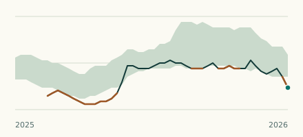 River gauge, United States Is the Yahara River unusually low at McFarland-Lk. Waubesa? Level now, history, the same date in past years and each year's range.
 Records, world Which places have set a new record low or high? Record lows and highs in our data, and the newest set.