Maine river levels today
Are the rivers and lakes in Maine unusually low or high?
We follow 55 water level gauges in Maine. 4 gauges read below their normal range for the date and none above it, not counting the 4 tide stations.
How many gauges do we follow in Maine?
55 gauges of the 7,007 we follow in the United States, as of 21 November 2026.
How many waters in Maine have a level gauge?
37 waters with a level gauge, of the 3,733 waters we follow in the United States, as of 21 November 2026.
How many gauges read below normal for the date?
4 gauges below their normal range, of the 5 gauges with a current reading and a normal range for the date, not counting the 4 tide stations, as of 21 November 2026.
How many gauges read above normal for the date?
0 gauges above their normal range, of the 5 gauges with a current reading and a normal range for the date, not counting the 4 tide stations, as of 21 November 2026.
How the places stand today
4 places below normal and 0 places above
Which places are furthest below normal?
Which gauges do we follow in Maine?
| Place | Reading | Against normal for the date | Change in a day |
|---|---|---|---|
| Allagash River | |||
| Allagash | 2.33 ft | -0.04 ft | |
| Androscoggin River | |||
| Auburn | 2.16 ft | -0.01 ft | |
| Rumford | 3.30 ft | -0.01 ft | |
| Aroostook River | |||
| Masardis | 2.91 ft | -0.07 ft | |
| Washburn | 1.46 ft | -0.06 ft | |
| Big Black River | |||
| Depot Mountain | 3.48 ft | -0.04 ft | |
| Carrabassett River | |||
| North Anson | 2.86 ft | -0.02 ft | |
| E. Branch of Penobscot | |||
| Grand Lake Matagamon | 2.43 ft | -0.01 ft | |
| Ellis River | |||
| South Andover | 4.71 ft | -0.02 ft | |
| Fish River | |||
| Fort Kent | 3.31 ft | -0.01 ft | |
| Forest City Stream | |||
| Forest City | 428.69 ft | 0 ft | |
| Grand Lake Stream | |||
| Grand Lake Stream | 1.77 ft | 0 ft | |
| Kenduskeag Stream | |||
| Bangor | 2.96 ft | -0.02 ft | |
| Kennebec River | |||
| Augusta | -1.94 ft | lower than any day of these dates in 28 years | +0.13 ft |
| Gardiner | -1.32 ft | lower than any day of these dates in 25 years | -0.34 ft |
| Hallowell | -1.96 ft | -0.04 ft | |
| North Sidney | 5.39 ft | 0 ft | |
| Kingsbury Stream | |||
| Abbot Village | 5.83 ft | -0.02 ft | |
| Lewy Lake | |||
| Princeton | 201.05 ft | within the normal range for the date | -0.01 ft |
| Little Madawaska River | |||
| Caribou | 3.37 ft | -0.03 ft | |
| Maine Coast | |||
| Bar Harbor | 0.085 m above the tide table | within the normal range for the date | |
| Cutler Farris Wharf | 0.061 m above the tide table | within the normal range for the date | |
| Eastport | 0.056 m above the tide table | within the normal range for the date | |
| Portland | 0.042 m above the tide table | within the normal range for the date | |
| Mattawamkeag River | |||
| Mattawamkeag | 4.81 ft | -0.08 ft | |
| Meduxnekeag River | |||
| South Branch near Houlton | 2.43 ft | -0.02 ft | |
| Narraguagus River | |||
| Cherryfield, Maine | 7.91 ft | -0.03 ft | |
| Nezinscot River | |||
| Turner Center | 1.21 ft | ||
| Old Stream | |||
| Wesley | 3.74 ft | 0 ft | |
| Pearce Brook | |||
| Houlton | 1.78 ft | -0.02 ft | |
| Penobscot River | |||
| Bangor | 0.40 ft | lower than any day of these dates in 14 years | -2.45 ft |
| Eddington | 2.46 ft | in the lowest 5 percent for the date | -0.03 ft |
| Grindstone | 4.50 ft | -0.01 ft | |
| West Enfield | 1.70 ft | -0.11 ft | |
| Piscataquis River | |||
| Blanchard | 3.54 ft | -0.03 ft | |
| Dover-Foxcroft | 1.80 ft | -0.02 ft | |
| Medford | 2.52 ft | -0.28 ft | |
| Presumpscot River | |||
| West Falmouth | 2.85 ft | +0.15 ft | |
| Royal River | |||
| Yarmouth | 0.98 ft | -0.03 ft | |
| Saco River | |||
| Cornish | 2.08 ft | -0.06 ft | |
| Sandy River | |||
| Madrid | 4.88 ft | 0 ft | |
| Mercer | 2.74 ft | -0.02 ft | |
| Sebec River | |||
| Sebec | 3.24 ft | -0.36 ft | |
| Seboeis River | |||
| Shin Pond | 4.44 ft | -0.02 ft | |
| Sheepscot River | |||
| North Whitefield | 1.85 ft | 0 ft | |
| St. Croix River | |||
| Baring | 4.34 ft | 0 ft | |
| Vanceboro | 4.24 ft | 0 ft | |
| St. Francis River | |||
| Connors | 3.07 ft | -0.03 ft | |
| St. John River | |||
| Dickey | 4.38 ft | -0.04 ft | |
| Edmundston | 441.17 ft | -0.28 ft | |
| Fort Kent | 4.13 ft | -0.04 ft | |
| Nine Mile Bridge | 1.39 ft | -0.06 ft | |
| Swift River | |||
| Roxbury | 1.11 ft | -0.01 ft | |
| Williams Brook | |||
| Presque Isle | 1.29 ft | +0.01 ft | |
| Wytopitlock Stream | |||
| Reed Plantation | 2.58 ft | -0.01 ft | |
Keep exploring
 Country, United States Are the rivers and lakes in the United States unusually low or high? Every river and lake we follow here, against normal for the date.
 Today's list, United States Which places in the United States are furthest from normal today? The places in the United States furthest below and above normal today.
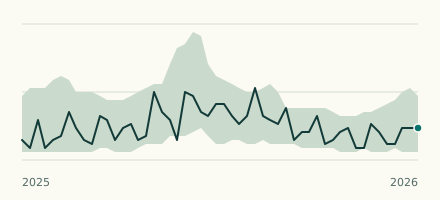 River gauge, United States Is the Kennebec River unusually low at Gardiner? Level now, history, the same date in past years and each year's range.
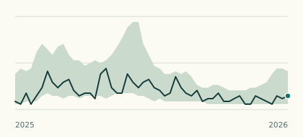 River gauge, United States Is the Kennebec River unusually low at Augusta? Level now, history, the same date in past years and each year's range.