Kentucky river levels today
Are the rivers and lakes in Kentucky unusually low or high?
We follow 86 water level gauges in Kentucky. 2 gauges read below their normal range for the date and none above it.
How many gauges do we follow in Kentucky?
86 gauges of the 7,007 we follow in the United States, as of 21 November 2026.
How many waters in Kentucky have a level gauge?
37 waters with a level gauge, of the 3,733 waters we follow in the United States, as of 21 November 2026.
How many gauges read below normal for the date?
2 gauges below their normal range, of the 14 gauges with a current reading and a normal range for the date, as of 21 November 2026.
How many gauges read above normal for the date?
0 gauges above their normal range, of the 14 gauges with a current reading and a normal range for the date, as of 21 November 2026.
How the places stand today
2 places below normal and 0 places above
Which places are furthest below normal?
Which gauges do we follow in Kentucky?
| Place | Reading | Against normal for the date | Change in a day |
|---|---|---|---|
| Banklick Creek | |||
| Erlanger | 1.06 ft | -0.02 ft | |
| Barren River | |||
| Barren River Lake | 30.58 ft | -0.43 ft | |
| Bowling Green | 6.36 ft | -1.20 ft | |
| Big Sandy River | |||
| Fullers Station | 3.51 ft | -0.22 ft | |
| Blaine Creek | |||
| Blaine | 3.07 ft | +0.01 ft | |
| Carr Creek | |||
| Carr Creek Lake | 19.28 ft | -0.26 ft | |
| Chenoweth Run | |||
| Fern Creek | 2.85 ft | 0 ft | |
| Cumberland River | |||
| Barbourville | 1.35 ft | -0.01 ft | |
| Burkesville | 29.20 ft | +1.21 ft | |
| Lake Cumberland | 688.37 ft | -0.25 ft | |
| Pineville | 6.52 ft | -0.01 ft | |
| Williamsburg | 2.81 ft | -0.03 ft | |
| Dix River | |||
| Herrington Lake | 727.12 ft | within the normal range for the date | -0.12 ft |
| Drakes Creek | |||
| Alvaton | 4.15 ft | -0.01 ft | |
| Eagle Creek | |||
| Glencoe | 1.60 ft | -0.02 ft | |
| Elijahs Creek | |||
| Hebron | 1.43 ft | -0.02 ft | |
| Elkhorn Creek | |||
| Peaks Mill | 2.32 ft | -0.02 ft | |
| Green River | |||
| Calhoun Lock and Dam | 11.85 ft | -0.07 ft | |
| Green River Lake | 71.95 ft | -0.77 ft | |
| Mammoth Cave | 13.11 ft | within the normal range for the date | +4.41 ft |
| Munfordville | 7.15 ft | +4.44 ft | |
| Paradise | 3.81 ft | within the normal range for the date | -0.12 ft |
| Rochester | 30.65 ft | -0.09 ft | |
| Woodbury | 7.20 ft | -0.58 ft | |
| Johns Creek | |||
| Dewey Lake | 647.24 ft | -0.07 ft | |
| Kentucky River | |||
| Camp Nelson | 11.97 ft | -0.06 ft | |
| Ford Lock | 10.14 ft | within the normal range for the date | -0.04 ft |
| Frankfort Lock | 7.19 ft | within the normal range for the date | -0.01 ft |
| Heidelberg | 9.77 ft | -0.03 ft | |
| High Bridge Lock | 9.34 ft | -0.11 ft | |
| Lockport | 8.93 ft | 0 ft | |
| Ravenna | 9.62 ft | -0.20 ft | |
| Valley View | 11.18 ft | -0.06 ft | |
| Levisa Fork | |||
| Fishtrap Lake | 745.61 ft | -0.48 ft | |
| Paintsville | 3.44 ft | -0.10 ft | |
| Pikeville | 7.00 ft | -0.10 ft | |
| Prestonsburg | 2.40 ft | -0.04 ft | |
| Licking River | |||
| Blue Licks Spring | 5.36 ft | -0.70 ft | |
| Catawba | 6.23 ft | -0.38 ft | |
| Cave Run Lake | 27.44 ft | -0.03 ft | |
| Falmouth | 2.12 ft | -0.38 ft | |
| McKinneysburg | 5.47 ft | -0.72 ft | |
| Salyersville | 4.87 ft | -0.01 ft | |
| Little Sandy River | |||
| Grayson | 5.31 ft | -0.01 ft | |
| Leon | 5.04 ft | -0.01 ft | |
| Middle Fork Kentucky River | |||
| Buckhorn Lake | 67.18 ft | -0.87 ft | |
| Mississippi River | |||
| Hickman | 6.50 ft | +0.28 ft | |
| Wickliffe | 13.23 ft | +0.41 ft | |
| Nolin River | |||
| Nolin River Lake | 96.92 ft | within the normal range for the date | -1.20 ft |
| North Fork Kentucky River | |||
| Hazard | 4.33 ft | -0.01 ft | |
| Jackson | 1.56 ft | -0.02 ft | |
| Whitesburg | 1.12 ft | -0.02 ft | |
| North Fork Licking River | |||
| Mount Olivet | 1.58 ft | +0.03 ft | |
| Ohio River | |||
| Ashland | 34.37 ft | -0.14 ft | |
| Henderson | 13.24 ft | within the normal range for the date | -0.28 ft |
| J.T. Myers Lock and Dam | 14.20 ft | ||
| Lloyd Greenup Lock | 12.81 ft | +0.04 ft | |
| Louisville Water Tower | 13.18 ft | +0.29 ft | |
| Madison | 13.37 ft | +0.20 ft | |
| Markland Lower | 15.16 ft | ||
| Maysville | 33.78 ft | in the lowest 10 percent for the date | -0.70 ft |
| McAlpine Lower | 11.12 ft | in the lowest 10 percent for the date | -1.43 ft |
| McAlpine Upper | 13.05 ft | within the normal range for the date | +0.33 ft |
| Owensboro | 19.14 ft | -0.42 ft | |
| Paducah | 15.88 ft | within the normal range for the date | +0.06 ft |
| Riverport at Owensboro | 19.14 ft | -0.42 ft | |
| Riverview Park | 10.65 ft | -1.20 ft | |
| Shawneetown | 16.09 ft | within the normal range for the date | +0.32 ft |
| Paint Creek | |||
| Paintsville Lake | 708.28 ft | -0.02 ft | |
| Poor Fork Cumberland River | |||
| Cumberland | 3.52 ft | +0.01 ft | |
| Red River | |||
| Clay City | 2.66 ft | 0 ft | |
| Rolling Fork River | |||
| Boston | 2.53 ft | -0.05 ft | |
| Rough River | |||
| Dundee | 7.67 ft | -1.45 ft | |
| Rough River Lake | 71.99 ft | -0.49 ft | |
| Russell Fork | |||
| Elkhorn City | 7.25 ft | -0.01 ft | |
| Salt River | |||
| Shepherdsville | 1.25 ft | -0.01 ft | |
| Taylorsville Lake | 45.51 ft | -0.03 ft | |
| South Fork Kentucky River | |||
| Booneville | 3.42 ft | -0.06 ft | |
| Oneida | 5.20 ft | 0 ft | |
| South Fork Licking River | |||
| Cynthiana | 5.02 ft | -0.01 ft | |
| South Fork Little River | |||
| Hopkinsville - 68/80 | 4.33 ft | +0.06 ft | |
| Hopkinsville - Bypass | 6.29 ft | within the normal range for the date | +0.01 ft |
| Stoner Creek | |||
| Paris | 13.20 ft | within the normal range for the date | +0.01 ft |
| Twelvemile Creek | |||
| Alexandria | 1.61 ft | -0.03 ft | |
| Tygarts Creek | |||
| Greenup | 2.59 ft | -0.01 ft | |
| Olive Hill | 1.00 ft | -0.01 ft | |
Keep exploring
 Country, United States Are the rivers and lakes in the United States unusually low or high? Every river and lake we follow here, against normal for the date.
 Today's list, United States Which places in the United States are furthest from normal today? The places in the United States furthest below and above normal today.
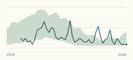 River gauge, United States Is the Ohio River unusually low at McAlpine Lower? Level now, history, the same date in past years and each year's range.
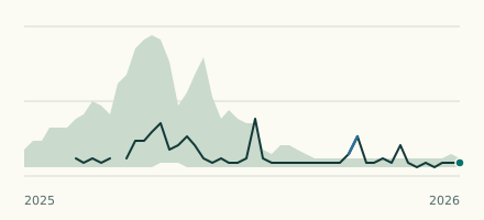 River gauge, United States Is the Ohio River unusually low at Maysville? Level now, history, the same date in past years and each year's range.