Aude département river levels today
Are the rivers and lakes in Aude unusually low or high?
We follow 82 water level gauges in Aude. 18 gauges read below their normal range for the date and none above it.
How many gauges do we follow in Aude?
82 gauges of the 3,038 we follow in France, as of 21 November 2026.
How many waters in Aude have a level gauge?
39 waters with a level gauge, of the 1,483 waters we follow in France, as of 21 November 2026.
How many gauges read below normal for the date?
18 gauges below their normal range, of the 36 gauges with a current reading and a normal range for the date, as of 21 November 2026.
How many gauges read above normal for the date?
0 gauges above their normal range, of the 36 gauges with a current reading and a normal range for the date, as of 21 November 2026.
How the places stand today
18 places below normal and 0 places above
Which places are furthest below normal?
More places
Which gauges do we follow in Aude?
| Place | Reading | Against normal for the date | Change in a day |
|---|---|---|---|
| Argent-Double | |||
| La Redorte | -0.101 m | in the lowest 5 percent for the date | 0 m |
| Trausse | -0.04 m | 0 m | |
| Aude | |||
| Alet-les-Bains | 0.133 m | -0.006 m | |
| Belvianes-et-Cavirac | 0.393 m | +0.158 m | |
| Carcassonne (Pont-Neuf) | 0.669 m | +0.071 m | |
| Carcassonne (Pont-Vieux) | 0.122 m | +0.009 m | |
| Coursan (Arminis) | 1.54 m | within the normal range for the date | +0.041 m |
| Coursan (Déversoir Grand Vigne) | 5.22 m | 0 m | |
| Coursan (Déversoir Prat du Raïs) | 6.50 m | 0 m | |
| Coursan (Village) | 0.611 m | in the lowest 10 percent for the date | +0.063 m |
| Cuxac-d'Aude | -2.633 m | lower than any day of these dates in 15 years | +0.045 m |
| Cuxac-d'Aude (Déversoir Horto de Blazy) | 9.413 m | ||
| Cuxac-d'Aude (Déversoirs 1952) | 9.097 m | ||
| Escouloubre | 0.237 m | within the normal range for the date | 0 m |
| Limoux | 0.669 m | -0.076 m | |
| Moussan | 0.165 m | in the lowest 5 percent for the date | +0.012 m |
| Puichéric | 0.743 m | -0.015 m | |
| Puichéric (downstream) | -0.096 m | -0.274 m | |
| Quillan | -0.067 m | -0.004 m | |
| Saint-Marcel-sur-Aude | 0.464 m | within the normal range for the date | +0.028 m |
| Sallèles-d'Aude | 12.68 m | +0.001 m | |
| Trèbes | 0.114 m | in the lowest 5 percent for the date | +0.007 m |
| Ventenac-en-Minervois | 0.17 m | lower than any day of these dates in 19 years | +0.028 m |
| Aussou | |||
| Saint-André-de-Roquelongue | 0.457 m | +0.006 m | |
| Barrou | |||
| Durban-Corbières | 0.672 m | +0.001 m | |
| Berre | |||
| Durban-Corbières | -0.329 m | within the normal range for the date | 0 m |
| Portel-des-Corbières | 1.083 m | within the normal range for the date | -0.001 m |
| Sigean | 11.18 m | 0 m | |
| Villesèque-des-Corbières | 0.093 m | within the normal range for the date | -0.001 m |
| Blau | |||
| Chalabre | 0.229 m | in the lowest 5 percent for the date | -0.005 m |
| Bruyante | |||
| Escouloubre | 0.199 m | within the normal range for the date | 0 m |
| Canal du Midi | |||
| Sallèles-d'Aude | 13.684 m | 0 m | |
| Cesse | |||
| Bize-Minervois | -1.051 m | in the lowest 5 percent for the date | +0.003 m |
| Mirepeisset | 0.226 m | within the normal range for the date | -0.001 m |
| Clamoux | |||
| Villeneuve-Minervois | 0.112 m | -0.001 m | |
| Corneilla | |||
| Bouriège | 0.111 m | 0 m | |
| Cougaing | |||
| Castelreng | -0.364 m | +0.033 m | |
| Fresquel | |||
| Alzonne | 0.31 m | -0.002 m | |
| Carcassonne | 0.309 m | within the normal range for the date | -0.013 m |
| Pezens | 0.169 m | within the normal range for the date | -0.021 m |
| Sainte-Eulalie | 0.285 m | -0.003 m | |
| Ventenac-Cabardès | -0.236 m | -0.018 m | |
| Villepinte | 0.112 m | in the lowest 10 percent for the date | -0.011 m |
| Gironde | |||
| Villeneuve-Minervois | 198.37 m | 0 m | |
| Lampy | |||
| Raissac-sur-Lampy | 0.288 m | within the normal range for the date | -0.026 m |
| Lauquet | |||
| Greffeil | 0.101 m | lower than any day of these dates in 49 years | -0.003 m |
| Verzeille | 0.328 m | +0.028 m | |
| Nielle | |||
| Saint-Laurent-de-la-Cabrerisse | 0.187 m | +0.001 m | |
| Ognon (Aude) | |||
| Pépieux | 0.168 m | within the normal range for the date | +0.002 m |
| Orbiel | |||
| Bouilhonnac | 0.023 m | lower than any day of these dates in 46 years | +0.013 m |
| Lastours | 0.456 m | in the lowest 5 percent for the date | -0.002 m |
| Orbieu | |||
| Lagrasse | -0.015 m | within the normal range for the date | +0.001 m |
| Luc-sur-Orbieu | -0.575 m | in the lowest 10 percent for the date | -0.001 m |
| Montjoi (Grotte St Pierre) | 0.424 m | ||
| Montjoi (Source de Montjoi) | 0.528 m | ||
| Saint-Martin-des-Puits | 0.212 m | in the lowest 10 percent for the date | -0.002 m |
| Termes | 0.366 m | ||
| Termes (Grotte de Nitable) | 1.344 m | ||
| Vignevieille | 0.184 m | ||
| Vignevieille (Grotte de Vignevieille) | -8.729 m | ||
| Villedaigne | 0.334 m | within the normal range for the date | -0.013 m |
| Rebenty | |||
| Saint-Martin-Lys | 0.049 m | in the lowest 5 percent for the date | -0.01 m |
| Rivière du Mas de Ségure | |||
| Tuchan | 0.889 m | -0.009 m | |
| Rougeanne | |||
| Moussoulens | -0.109 m | in the lowest 5 percent for the date | -0.013 m |
| Ruisseau d'Aymes | |||
| Bize-Minervois | 1.712 m | ||
| Ruisseau de Canet | |||
| Badens | 80.94 m | ||
| Ruisseau de Dons | |||
| Vinassan | 30.651 m | ||
| Ruisseau de la Font Intruse | |||
| Fabrezan | 83.927 m | 0 m | |
| Ruisseau de Lavalette | |||
| Alet-les-Bains | 0.058 m | lower than any day of these dates in 23 years | -0.009 m |
| Ruisseau de Mayral | |||
| Rustiques | 127.749 m | 0 m | |
| Ruisseau de Palajanel | |||
| Cazilhac | 141.068 m | -0.001 m | |
| Palaja | 152.293 m | +0.002 m | |
| Ruisseau de Tenten | |||
| Saint-Martin-le-Vieil | 0.224 m | ||
| Ruisseau de Trapel | |||
| Villegailhenc | -0.98 m | -0.058 m | |
| Ruisseau du Répudre | |||
| Mailhac | 0.031 m | +0.004 m | |
| Ruisseau du Veyret | |||
| Narbonne | 14.519 m | -0.006 m | |
| Sals | |||
| Cassaignes | 0.146 m | within the normal range for the date | +0.001 m |
| Sou | |||
| Lagrasse | 0.175 m | in the lowest 10 percent for the date | -0.008 m |
| Saint-Martin-de-Villereglan | 0.229 m | within the normal range for the date | -0.002 m |
| Verdouble | |||
| Padern | 2.28 m | within the normal range for the date | -0.014 m |
| Vernassonne | |||
| Alzonne | 0.031 m | -0.009 m | |
| Vixiège | |||
| Belpech | 0.087 m | within the normal range for the date | +0.001 m |
Keep exploring
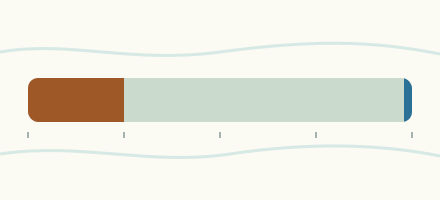 Country, France Are the rivers and lakes in France unusually low or high? Every river and lake we follow in France, against normal for the date.
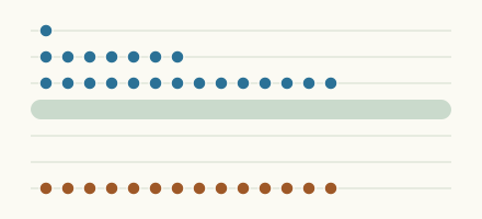 Today's list, France Which places in France are furthest from normal today? The places in France furthest below and above normal today.
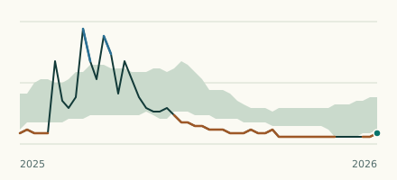 River gauge, France Is the Lauquet unusually low at Greffeil? Level now, history, the same date in past years and each year's range.
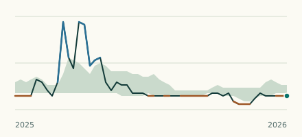 River gauge, France Is the Aude unusually low at Ventenac-en-Minervois? Level now, history, the same date in past years and each year's range.
Sources
- Source : Hub'Eau / SCV, données PHyC (Licence Ouverte Etalab) (source). Licence: Licence Ouverte / Open Licence version 2.0