Witham catchment river levels today
Are the rivers and lakes in the Witham catchment unusually low or high?
We follow 47 water level gauges in the Witham catchment. 1 gauge reads below its normal range for the date and 1 gauge above it.
How many gauges do we follow in the Witham catchment?
47 gauges of the 2,378 we follow in the United Kingdom, as of 21 November 2026.
How many waters in the Witham catchment have a level gauge?
23 waters with a level gauge, of the 1,152 waters we follow in the United Kingdom, as of 21 November 2026.
How many gauges read below normal for the date?
1 gauge below its normal range, of the 9 gauges with a current reading and a normal range for the date, as of 21 November 2026.
How many gauges read above normal for the date?
1 gauge above its normal range, of the 9 gauges with a current reading and a normal range for the date, as of 21 November 2026.
How the places stand today
1 place below normal and 1 place above
Which places are furthest below normal?
Which places are furthest above normal?
Which gauges do we follow in Witham?
| Place | Reading | Against normal for the date | Change in a day |
|---|---|---|---|
| Barlings Eau | |||
| Langworth | 0.233 m | within the normal range for the date | -0.015 m |
| Billinghay Skirth | |||
| Billinghay | 0.636 m | -0.077 m | |
| East Fen Catchwater | |||
| Toynton Fenside | 0.405 m | -0.043 m | |
| Fosdyke Canal | |||
| Fosdyke Jetty | 1.333 m | +0.013 m | |
| Foston Beck | |||
| Allington | 0.105 m | within the normal range for the date | -0.049 m |
| Hagnaby Beck | |||
| Hagnaby Beck | 0.081 m | within the normal range for the date | -0.037 m |
| Heighington Beck | |||
| Heighington Beck | 0.043 m | -0.003 m | |
| Maud Foster/Stonebridge Drain | |||
| Cowbridge | 0.987 m | +0.043 m | |
| Sibsey | 0.846 m | in the highest 5 percent for the date | -0.093 m |
| Nettleham Beck | |||
| Nettleham | 0.068 m | within the normal range for the date | -0.003 m |
| Pointon Lode | |||
| Pointon Lode | 0.018 m | within the normal range for the date | -0.003 m |
| River Bain | |||
| Goulceby | 0.064 m | -0.027 m | |
| Horncastle Victoria Mill | 0.199 m | -0.079 m | |
| Kirkby On Bain | 0.19 m | -0.201 m | |
| River Brant | |||
| Brant Broughton | 0.173 m | within the normal range for the date | -0.078 m |
| Horseshoe Bridge | 0.564 m | -0.296 m | |
| River Lymn | |||
| Partney | 0.092 m | -0.072 m | |
| River Slea | |||
| Cranwell Line Sluice | 0.094 m | -0.001 m | |
| Leasingham Mill | 0.02 m | in the lowest 5 percent for the date | -0.011 m |
| Slea Tilting Gate | 0.33 m | -0.008 m | |
| River Steeping | |||
| Wainfleet | 0.369 m | +0.008 m | |
| River Till (Lincolnshire) | |||
| Squires Bridge | 0.934 m | -0.194 m | |
| River Waring | |||
| Horncastle Banks Road | 0.156 m | -0.102 m | |
| River Witham | |||
| Bardney | 1.068 m | -0.064 m | |
| Bargate Weir | 0.183 m | +0.009 m | |
| Bracebridge | 0.426 m | +0.011 m | |
| Brayford Pool | 0.293 m | +0.011 m | |
| Chapel Hill | 1.116 m | -0.133 m | |
| Claypole | 0.197 m | -0.057 m | |
| Colsterworth | 0.135 m | -0.023 m | |
| Fiskerton Sluice | 0.222 m | +0.019 m | |
| Hougham | 0.837 m | -0.074 m | |
| Kirkstead Bridge | 0.914 m | -0.051 m | |
| Langrick Bridge | 1.326 m | -0.158 m | |
| North Hykeham | 0.333 m | +0.015 m | |
| North Witham | 0.125 m | 0 m | |
| Saltersford | 0.182 m | +0.017 m | |
| Stamp End Sluice | 0.887 m | +0.015 m | |
| Ruskington Beck | |||
| Ruskington Beck | 0.304 m | -0.072 m | |
| Sincil Dyke | |||
| Lincoln Monson Street | 0.22 m | +0.009 m | |
| South Forty Foot Drain | |||
| Billingborough Ousemere | 0.085 m | -0.035 m | |
| Donington Bridge | 0.213 m | -0.061 m | |
| Dowsby Fen | 0.251 m | -0.101 m | |
| Swaton | 0.276 m | -0.109 m | |
| Stainfield Beck | |||
| Stainfield Beck | 0.131 m | within the normal range for the date | -0.048 m |
| West Fen Catchwater Drain | |||
| New York | 0.308 m | -0.042 m | |
| Revesby | 0.409 m | -0.118 m | |
Keep exploring
 Country, United Kingdom Are the rivers and lakes in the United Kingdom unusually low or high? Every river and lake we follow here, against normal for the date.
 Today's list, United Kingdom Which places in the United Kingdom are furthest from normal today? The places in the United Kingdom furthest below and above normal today.
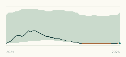 River gauge, United Kingdom Is the River Slea unusually low at Leasingham Mill? Level now, history, the same date in past years and each year's range.
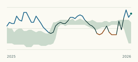 River gauge, United Kingdom Is the Maud Foster/Stonebridge Drain unusually high at Sibsey? Level now, history, the same date in past years and each year's range.