Upper Mersey catchment river levels today
Are the rivers and lakes in the Upper Mersey catchment unusually low or high?
We follow 30 water level gauges in the Upper Mersey catchment. None read below their normal range for the date and 1 gauge above it.
How many gauges do we follow in the Upper Mersey catchment?
30 gauges of the 2,378 we follow in the United Kingdom, as of 21 November 2026.
How many waters in the Upper Mersey catchment have a level gauge?
17 waters with a level gauge, of the 1,152 waters we follow in the United Kingdom, as of 21 November 2026.
How many gauges read below normal for the date?
0 gauges below their normal range, of the 19 gauges with a current reading and a normal range for the date, as of 21 November 2026.
How many gauges read above normal for the date?
1 gauge above its normal range, of the 19 gauges with a current reading and a normal range for the date, as of 21 November 2026.
How the places stand today
0 places below normal and 1 place above
Which places are furthest above normal?
Which gauges do we follow in Upper Mersey?
| Place | Reading | Against normal for the date | Change in a day |
|---|---|---|---|
| Baguley Brook | |||
| Northern Moor | 0.239 m | within the normal range for the date | -0.015 m |
| Chorlton Brook | |||
| Lavington Avenue Debris Screen | 0.455 m | higher than any day of these dates in 23 years | +0.005 m |
| Cringle Brook | |||
| Cringle Brook Debris Screen | 0.036 m | -0.005 m | |
| Glossop Brook | |||
| High Street West | 0.115 m | -0.021 m | |
| Micker Brook | |||
| Bramhall Green Bridge Lane | 0.188 m | -0.062 m | |
| Micklehurst Brook | |||
| Mossley Micklehurst Road | 0.935 m | 0 m | |
| Platt Brook | |||
| Brighton Grove Debris Screen | 0.282 m | within the normal range for the date | -0.013 m |
| Poise Brook | |||
| Poise Brook Debris Screen | 0.134 m | within the normal range for the date | -0.018 m |
| Poynton Brook | |||
| Poynton | 0.281 m | within the normal range for the date | -0.073 m |
| River Bollin | |||
| Bollington Mill | 0.376 m | within the normal range for the date | +0.004 m |
| Old Mill Lane | 0.163 m | -0.013 m | |
| Prestbury | 0.342 m | within the normal range for the date | -0.035 m |
| Wilmslow | 0.268 m | ||
| River Dean | |||
| Stanneylands | 0.164 m | within the normal range for the date | -0.039 m |
| River Etherow | |||
| Compstall | 0.139 m | within the normal range for the date | -0.027 m |
| Woolley Bridge | 0.382 m | within the normal range for the date | +0.005 m |
| River Goyt | |||
| Goytside Farm | 0.655 m | within the normal range for the date | -0.025 m |
| Marple Bridge | 0.236 m | within the normal range for the date | -0.052 m |
| River Mersey | |||
| Ashton Weir | 0.439 m | within the normal range for the date | -0.058 m |
| Brinksway | 0.572 m | within the normal range for the date | -0.064 m |
| Didsbury River | 2.762 m | -0.152 m | |
| Flixton Bridge | 0.434 m | -0.048 m | |
| Northenden | 0.316 m | within the normal range for the date | -0.054 m |
| River Tame (Greater Manchester) | |||
| Broomstairs Bridge | 0.265 m | -0.04 m | |
| Delph | 0.15 m | within the normal range for the date | -0.021 m |
| Portwood | 0.14 m | within the normal range for the date | -0.037 m |
| Uppermill | 0.095 m | within the normal range for the date | -0.024 m |
| Waggon Road | 0.535 m | -0.035 m | |
| Sinderland Brook | |||
| Partington | 0.166 m | within the normal range for the date | -0.036 m |
| Whittle Brook | |||
| Walkden The Reach | 0.166 m | -0.051 m | |
Keep exploring
 Country, United Kingdom Are the rivers and lakes in the United Kingdom unusually low or high? Every river and lake we follow here, against normal for the date.
 Today's list, United Kingdom Which places in the United Kingdom are furthest from normal today? The places in the United Kingdom furthest below and above normal today.
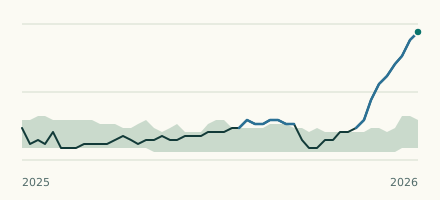 River gauge, United Kingdom Is the Chorlton Brook unusually high at Lavington Avenue Debris Screen? Level now, history, the same date in past years and each year's range.
 Records, world Which places have set a new record low or high? Record lows and highs in our data, and the newest set.