Staffordshire Trent Valley catchment river levels today
Are the rivers and lakes in the Staffordshire Trent Valley catchment unusually low or high?
We follow 23 water level gauges in the Staffordshire Trent Valley catchment. 1 gauge reads below its normal range for the date and none above it.
How many gauges do we follow in the Staffordshire Trent Valley catchment?
23 gauges of the 2,378 we follow in the United Kingdom, as of 21 November 2026.
How many waters in the Staffordshire Trent Valley catchment have a level gauge?
14 waters with a level gauge, of the 1,152 waters we follow in the United Kingdom, as of 21 November 2026.
How many gauges read below normal for the date?
1 gauge below its normal range, of the 15 gauges with a current reading and a normal range for the date, as of 21 November 2026.
How many gauges read above normal for the date?
0 gauges above their normal range, of the 15 gauges with a current reading and a normal range for the date, as of 21 November 2026.
How the places stand today
1 place below normal and 0 places above
Which places are furthest below normal?
Which gauges do we follow in Staffordshire Trent Valley?
| Place | Reading | Against normal for the date | Change in a day |
|---|---|---|---|
| Ford Green Brook | |||
| Brookhouse Farm | 0.307 m | -0.081 m | |
| Fowlea Brook | |||
| Liverpool Road, Stoke-On-Trent | 0.075 m | in the lowest 10 percent for the date | -0.233 m |
| Lyme Brook | |||
| Newcastle Under Lyme | 0.274 m | within the normal range for the date | -0.021 m |
| Meece Brook | |||
| Shallowford | 0.247 m | -0.029 m | |
| Ridings Brook | |||
| Cannock | 0.215 m | within the normal range for the date | -0.042 m |
| Rising Brook | |||
| Stafford | 0.083 m | within the normal range for the date | -0.011 m |
| River Blithe | |||
| Blythe Bridge | 0.348 m | -0.031 m | |
| Hamstall Ridware | 0.149 m | -0.033 m | |
| River Mease | |||
| Clifton Hall | 0.555 m | within the normal range for the date | -0.182 m |
| River Penk | |||
| Coven | 0.745 m | -0.078 m | |
| Penkridge | 0.409 m | within the normal range for the date | -0.193 m |
| River Sow | |||
| Broadeye Bridge | 0.646 m | -0.039 m | |
| Great Bridgford | 0.489 m | within the normal range for the date | -0.139 m |
| Milford | 1.015 m | within the normal range for the date | -0.146 m |
| River Swarbourne | |||
| Hoar Cross | 0.253 m | -0.052 m | |
| River Trent | |||
| Bucknall | 0.152 m | within the normal range for the date | -0.065 m |
| Darlaston | 0.843 m | within the normal range for the date | -0.191 m |
| Great Haywood | 0.97 m | within the normal range for the date | -0.196 m |
| Hanford Bridge | 0.501 m | -0.096 m | |
| Kings Bromley | 1.016 m | within the normal range for the date | -0.118 m |
| Knypersley | 0.422 m | within the normal range for the date | -0.018 m |
| Sandyford Brook | |||
| Astonfields | 0.312 m | within the normal range for the date | -0.049 m |
| Saredon Brook | |||
| Deepmore Farm | 0.496 m | within the normal range for the date | -0.077 m |
Keep exploring
 Country, United Kingdom Are the rivers and lakes in the United Kingdom unusually low or high? Every river and lake we follow here, against normal for the date.
 Today's list, United Kingdom Which places in the United Kingdom are furthest from normal today? The places in the United Kingdom furthest below and above normal today.
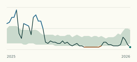 River gauge, United Kingdom Is the Fowlea Brook unusually low at Liverpool Road, Stoke-On-Trent? Level now, history, the same date in past years and each year's range.
 Records, world Which places have set a new record low or high? Record lows and highs in our data, and the newest set.