Parrett, Brue and West Somerset Streams catchment river levels today
Are the rivers and lakes in the Parrett, Brue and West Somerset Streams catchment unusually low or high?
We follow 51 water level gauges in the Parrett, Brue and West Somerset Streams catchment.
How many gauges do we follow in the Parrett, Brue and West Somerset Streams catchment?
51 gauges of the 2,378 we follow in the United Kingdom, as of 21 November 2026.
How many waters in the Parrett, Brue and West Somerset Streams catchment have a level gauge?
28 waters with a level gauge, of the 1,152 waters we follow in the United Kingdom, as of 21 November 2026.
How many gauges read below normal for the date?
1 gauge below its normal range, of the 25 gauges with a current reading and a normal range for the date, as of 21 November 2026.
How many gauges read above normal for the date?
2 gauges above their normal range, of the 25 gauges with a current reading and a normal range for the date, as of 21 November 2026.
How the places stand today
1 place below normal and 2 places above
Which places are furthest below normal?
Which places are furthest above normal?
Which gauges do we follow in Parrett, Brue and West Somerset Streams?
| Place | Reading | Against normal for the date | Change in a day |
|---|---|---|---|
| Cannington Brook | |||
| Cannington | 0.349 m | within the normal range for the date | -0.05 m |
| Currymoor Drain | |||
| Currymoor Pumping Station | 4.429 m | -0.034 m | |
| Doniford Stream | |||
| Sampford Brett | 0.091 m | -0.09 m | |
| Stogumber Escott Lane | 0.128 m | -0.01 m | |
| Swill Bridge | 0.301 m | within the normal range for the date | -0.044 m |
| Halse Water | |||
| Halsewater | 0.309 m | -0.097 m | |
| Hawkcombe Stream | |||
| Parsons Street | 0.409 m | higher than any day of these dates in 22 years | -0.016 m |
| Hillfarrance Brook | |||
| Milverton | 0.251 m | within the normal range for the date | -0.049 m |
| Horner Water | |||
| West Luccombe | 0.24 m | within the normal range for the date | -0.029 m |
| Huish Level Rhyne | |||
| Westover Pumping Station | 0.955 m | -0.03 m | |
| Kings Sedgemoor Drain | |||
| Bradney | 3.002 m | in the highest 10 percent for the date | +0.21 m |
| Dunball | 2.99 m | +0.181 m | |
| Longload Main Drain | |||
| Huish Episcopi Pumping Station | 1.278 m | +0.005 m | |
| Monksilver Stream | |||
| Williton | 0.13 m | +0.011 m | |
| North Drain | |||
| North Drain | 1.761 m | within the normal range for the date | -0.097 m |
| Northmoor Main Drain | |||
| Northmoor Drain | 3.265 m | within the normal range for the date | +0.006 m |
| Northmoor Pumping Station | 2.366 m | +0.094 m | |
| Old River Tone | |||
| Bathpool Outfall | 8.038 m | -0.622 m | |
| River Aller | |||
| Allerford | 0.015 m | within the normal range for the date | -0.064 m |
| River Brue | |||
| Bruton Dam | 0.909 m | -0.653 m | |
| Bruton Surgery | 0.442 m | -0.131 m | |
| Clyse Hole | 0.362 m | within the normal range for the date | -0.114 m |
| Lovington | 0.335 m | within the normal range for the date | -0.359 m |
| River Cam (Somerset) | |||
| Weston Bampfylde | 0.116 m | within the normal range for the date | -0.086 m |
| River Isle | |||
| Ashford Mill | 0.212 m | within the normal range for the date | -0.19 m |
| Donyatt | 0.343 m | -0.113 m | |
| Midelney | 1.62 m | +1.964 m | |
| River Parrett | |||
| Chiselborough | 0.139 m | within the normal range for the date | -0.245 m |
| Dunball Tidal | 0.919 m | +0.002 m | |
| Gaw Bridge | 0.612 m | -0.477 m | |
| West Quay | 1.99 m | in the lowest 10 percent for the date | -0.117 m |
| West Sedgemoor Pumping Station | 5.889 m | within the normal range for the date | -1.062 m |
| River Sheppey | |||
| Fenny Castle | 0.295 m | within the normal range for the date | -0.096 m |
| Shepton Mallet Garston Street | 0.032 m | 0 m | |
| Shepton Mallet Lower Lane | 0.103 m | -0.028 m | |
| River Sowy | |||
| Beerwall Upstream | 3.992 m | within the normal range for the date | +0.04 m |
| River Tone | |||
| Bathpool Outfall | 7.986 m | -0.662 m | |
| Bishops Hull | 0.463 m | within the normal range for the date | -0.187 m |
| Currymoor Pumping Station | 6.175 m | -0.529 m | |
| Greenham | 0.38 m | within the normal range for the date | -0.048 m |
| Taunton Market | 0.931 m | within the normal range for the date | -0.092 m |
| River Wriggle | |||
| Chetnole | 0.178 m | within the normal range for the date | -0.099 m |
| River Yeo | |||
| Huish Episcopi Pumping Station | 1.962 m | -0.326 m | |
| Ilchester | 0.372 m | -0.322 m | |
| Pen Mill | 0.264 m | within the normal range for the date | -0.105 m |
| Sherborne Lake | 0.033 m | +0.145 m | |
| Saltmoor Main Drain | |||
| Baltmoor Wall Saltmoor Barrier | 3.823 m | within the normal range for the date | -0.057 m |
| Washford River | |||
| Beggearn Huish | 0.414 m | within the normal range for the date | -0.003 m |
| Luxborough | 0.304 m | -0.009 m | |
| West Moor Drain | |||
| Midelney | 0.954 m | +0.058 m | |
| Witcombe Bottom Main Drain | |||
| Long Load | 7.367 m | +0.031 m | |
Keep exploring
 Country, United Kingdom Are the rivers and lakes in the United Kingdom unusually low or high? Every river and lake we follow here, against normal for the date.
 Today's list, United Kingdom Which places in the United Kingdom are furthest from normal today? The places in the United Kingdom furthest below and above normal today.
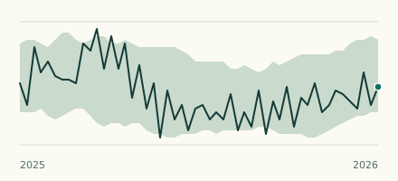 River gauge, United Kingdom Is the River Parrett unusually low at West Quay? Level now, history, the same date in past years and each year's range.
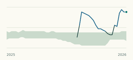 River gauge, United Kingdom Is the Hawkcombe Stream unusually high at Parsons Street? Level now, history, the same date in past years and each year's range.