Dove catchment river levels today
Are the rivers and lakes in the Dove catchment unusually low or high?
We follow 26 water level gauges in the Dove catchment. 2 gauges read below their normal range for the date and none above it.
How many gauges do we follow in the Dove catchment?
26 gauges of the 2,378 we follow in the United Kingdom, as of 21 November 2026.
How many waters in the Dove catchment have a level gauge?
14 waters with a level gauge, of the 1,152 waters we follow in the United Kingdom, as of 21 November 2026.
How many gauges read below normal for the date?
2 gauges below their normal range, of the 24 gauges with a current reading and a normal range for the date, as of 21 November 2026.
How many gauges read above normal for the date?
0 gauges above their normal range, of the 24 gauges with a current reading and a normal range for the date, as of 21 November 2026.
How the places stand today
2 places below normal and 0 places above
Which places are furthest below normal?
Which gauges do we follow in Dove?
| Place | Reading | Against normal for the date | Change in a day |
|---|---|---|---|
| Egginton Brook | |||
| Egginton | 0.259 m | within the normal range for the date | -0.136 m |
| Endon Brook | |||
| Wallgrange | 0.192 m | within the normal range for the date | -0.097 m |
| Foston Brook | |||
| Horsebottoms | 0.362 m | within the normal range for the date | -0.06 m |
| Henmore Brook | |||
| Agnes Meadow | 0.169 m | within the normal range for the date | -0.047 m |
| Ashbourne | 0.209 m | within the normal range for the date | -0.048 m |
| Hilton Brook | |||
| Sutton Mill | 0.685 m | within the normal range for the date | -0.092 m |
| Marchington Brook | |||
| Marchington | 0.183 m | within the normal range for the date | -0.03 m |
| Picknall Brook | |||
| Uttoxeter Park | 0.289 m | within the normal range for the date | -0.019 m |
| River Blithe | |||
| Cresswell | 0.214 m | within the normal range for the date | -0.044 m |
| River Churnet | |||
| Basford Bridge | 0.356 m | within the normal range for the date | -0.145 m |
| Flint Mill | 0.241 m | within the normal range for the date | -0.247 m |
| Froghall | 0.405 m | within the normal range for the date | -0.18 m |
| Leek | 0.172 m | in the lowest 5 percent for the date | +0.005 m |
| Quixhill | 0.359 m | within the normal range for the date | -0.138 m |
| River Dove | |||
| Aston Bridge | 0.956 m | within the normal range for the date | -0.339 m |
| Doveridge | 0.848 m | within the normal range for the date | -0.156 m |
| Hatton | 0.649 m | within the normal range for the date | -0.308 m |
| Izaak Walton | 0.259 m | ||
| Marston on Dove | 0.646 m | within the normal range for the date | -0.125 m |
| Mayfield | 0.463 m | within the normal range for the date | -0.108 m |
| Rocester | 0.282 m | within the normal range for the date | -0.082 m |
| River Hamps | |||
| Waterhouses | 0.262 m | within the normal range for the date | -0.063 m |
| River Manifold | |||
| Ilam | 0.242 m | -0.068 m | |
| River Tean | |||
| Leasows Farm | 0.447 m | within the normal range for the date | -0.065 m |
| Upper Tean | 0.232 m | in the lowest 10 percent for the date | -0.034 m |
| Rolleston Brook | |||
| Anslow | 0.318 m | within the normal range for the date | -0.02 m |
Keep exploring
 Country, United Kingdom Are the rivers and lakes in the United Kingdom unusually low or high? Every river and lake we follow here, against normal for the date.
 Today's list, United Kingdom Which places in the United Kingdom are furthest from normal today? The places in the United Kingdom furthest below and above normal today.
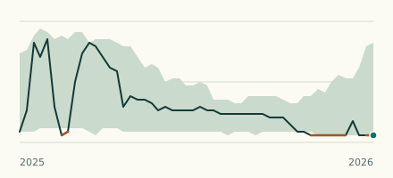 River gauge, United Kingdom Is the River Churnet unusually low at Leek? Level now, history, the same date in past years and each year's range.
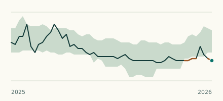 River gauge, United Kingdom Is the River Tean unusually low at Upper Tean? Level now, history, the same date in past years and each year's range.