Bristol Avon, Little Avon, Axe and North Somerset Streams catchment river levels today
Are the rivers and lakes here unusually low or high?
We follow 58 water level gauges in the Bristol Avon, Little Avon, Axe and North Somerset Streams catchment.
How many gauges do we follow in the Bristol Avon, Little Avon, Axe and North Somerset Streams catchment?
58 gauges of the 2,378 we follow in the United Kingdom, as of 21 November 2026.
How many waters in the Bristol Avon, Little Avon, Axe and North Somerset Streams catchment have a level gauge?
33 waters with a level gauge, of the 1,152 waters we follow in the United Kingdom, as of 21 November 2026.
How many gauges read below normal for the date?
1 gauge below its normal range, of the 37 gauges with a current reading and a normal range for the date, as of 21 November 2026.
How many gauges read above normal for the date?
0 gauges above their normal range, of the 37 gauges with a current reading and a normal range for the date, as of 21 November 2026.
How the places stand today
1 place below normal and 0 places above
Which places are furthest below normal?
Which gauges do we follow in Bristol Avon, Little Avon, Axe and North Somerset Streams?
| Place | Reading | Against normal for the date | Change in a day |
|---|---|---|---|
| Bradley Brook | |||
| Bradley Bridge | 0.19 m | within the normal range for the date | -0.145 m |
| Brinkworth Brook | |||
| Brinkworth Brook | 0.708 m | within the normal range for the date | -0.28 m |
| Hancocks Water Reservoir | 4.32 m | -0.037 m | |
| Brislington Brook | |||
| Brislington | 0.035 m | lower than any day of these dates in 17 years | -0.034 m |
| Bristol Frome | |||
| Bristol Harbour Passage Street | 6.194 m | within the normal range for the date | -0.01 m |
| Bristol Wade Street | 5.974 m | -0.005 m | |
| Chipping Sodbury | 0.609 m | within the normal range for the date | -0.173 m |
| Eastville | 7.593 m | -0.332 m | |
| Frampton Cotterell | 0.257 m | within the normal range for the date | -0.067 m |
| Frenchay | 0.909 m | within the normal range for the date | -0.194 m |
| Tubbs Bottom | 0.403 m | -0.118 m | |
| By Brook | |||
| Middlehill | 0.686 m | within the normal range for the date | -0.102 m |
| West Kington | 0.175 m | -0.028 m | |
| Cheddar Yeo | |||
| Cheddar Gorge | 0.255 m | -0.029 m | |
| Chew Stoke Brook | |||
| Chew Stoke | 0.091 m | within the normal range for the date | -0.048 m |
| Clackers Brook | |||
| Melksham Clackers | 0.125 m | -0.156 m | |
| Colliters Brook | |||
| Colliters Brook | 0.156 m | within the normal range for the date | -0.135 m |
| Congresbury Yeo | |||
| Congresbury | 5.736 m | -0.15 m | |
| Iwood | 0.215 m | within the normal range for the date | -0.084 m |
| Dauntsey Brook | |||
| Dauntsey | 0.217 m | within the normal range for the date | -0.205 m |
| Gauze Brook | |||
| Rodbourne | 0.321 m | within the normal range for the date | -0.068 m |
| Lambrok Stream | |||
| Trowbridge Southwick | 0.268 m | -0.039 m | |
| Land Yeo | |||
| Wraxall | 0.401 m | -0.16 m | |
| Little Avon River | |||
| Berkeley | 0.339 m | within the normal range for the date | -0.165 m |
| Mells River | |||
| Stoke Bottom Farm | 0.117 m | within the normal range for the date | -0.022 m |
| Vallis | 0.284 m | within the normal range for the date | -0.079 m |
| Midford Brook | |||
| Midford | 1.02 m | within the normal range for the date | -0.189 m |
| Nunney Brook | |||
| Holwell | 0.823 m | within the normal range for the date | -0.098 m |
| River Avon (Bristol) | |||
| Ashton Vale | 0.948 m | -0.036 m | |
| Bath Destructor Bridge | 3.539 m | -0.038 m | |
| Bathford | 1.153 m | within the normal range for the date | -0.204 m |
| Bradford on Avon | 1.325 m | within the normal range for the date | -0.14 m |
| Bristol Bedminster St Johns Lane Downstream | 0.353 m | -0.014 m | |
| Bristol Bedminster St Johns Lane Upstream | 0.353 m | -0.015 m | |
| Bristol Netham Lock | 6.137 m | -0.013 m | |
| Great Somerford | 0.616 m | within the normal range for the date | -0.101 m |
| Keynsham, Rivermead | 5.026 m | -0.147 m | |
| Netham Weir | 0.471 m | -0.093 m | |
| Saltford | 0.809 m | -0.106 m | |
| River Axe (Somerset) | |||
| Wookey | 0.662 m | within the normal range for the date | -0.052 m |
| River Biss | |||
| Trowbridge | 0.257 m | within the normal range for the date | -0.051 m |
| River Boyd | |||
| Bitton | 0.321 m | within the normal range for the date | -0.088 m |
| Wick | 0.243 m | within the normal range for the date | -0.078 m |
| River Chew | |||
| Compton Dando | 0.771 m | within the normal range for the date | -0.175 m |
| River Marden | |||
| Calne | 0.174 m | within the normal range for the date | -0.04 m |
| Stanley | 0.589 m | within the normal range for the date | -0.18 m |
| River Trym | |||
| Filton Southmead Road | 0.02 m | -0.003 m | |
| Semington Brook | |||
| Semington | 0.361 m | within the normal range for the date | -0.034 m |
| Sherston Avon | |||
| Fosseway | 0.505 m | within the normal range for the date | +0.016 m |
| St Johns Weir | 0.427 m | -0.029 m | |
| Somerset Frome | |||
| Frome Rodden | 0.509 m | within the normal range for the date | -0.091 m |
| Tellisford | 1.086 m | within the normal range for the date | -0.216 m |
| South Brook | |||
| Melksham Shaw | 0.169 m | -0.054 m | |
| Tetbury Avon | |||
| Brokenborough | 0.392 m | within the normal range for the date | -0.122 m |
| Wellow Brook | |||
| Wellow | 0.768 m | within the normal range for the date | -0.092 m |
| Welton | 0.122 m | within the normal range for the date | -0.021 m |
| Winford Brook | |||
| Chew Magna Level | 0.165 m | within the normal range for the date | -0.002 m |
| Woodbridge Brook | |||
| Crabb Mill | 0.462 m | within the normal range for the date | -0.32 m |
Keep exploring
 Country, United Kingdom Are the rivers and lakes in the United Kingdom unusually low or high? Every river and lake we follow here, against normal for the date.
 Today's list, United Kingdom Which places in the United Kingdom are furthest from normal today? The places in the United Kingdom furthest below and above normal today.
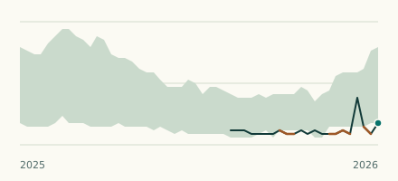 River gauge, United Kingdom Is the Brislington Brook unusually low at Brislington? Level now, history, the same date in past years and each year's range.
 Records, world Which places have set a new record low or high? Record lows and highs in our data, and the newest set.