Aire and Calder catchment river levels today
Are the rivers and lakes in the Aire and Calder catchment unusually low or high?
We follow 120 water level gauges in the Aire and Calder catchment. 19 gauges read below their normal range for the date and 1 gauge above it.
How many gauges do we follow in the Aire and Calder catchment?
120 gauges of the 2,378 we follow in the United Kingdom, as of 21 November 2026.
How many waters in the Aire and Calder catchment have a level gauge?
52 waters with a level gauge, of the 1,152 waters we follow in the United Kingdom, as of 21 November 2026.
How many gauges read below normal for the date?
19 gauges below their normal range, of the 97 gauges with a current reading and a normal range for the date, as of 21 November 2026.
How many gauges read above normal for the date?
1 gauge above its normal range, of the 97 gauges with a current reading and a normal range for the date, as of 21 November 2026.
How the places stand today
19 places below normal and 1 place above
Which places are furthest below normal?
More places
Which places are furthest above normal?
Which gauges do we follow in Aire and Calder?
| Place | Reading | Against normal for the date | Change in a day |
|---|---|---|---|
| Aire Washlands | |||
| Allerton Ings | 0.025 m | within the normal range for the date | -0.001 m |
| Fairburn Sluices | 0.488 m | within the normal range for the date | -0.026 m |
| Mickletown Ings | 0.391 m | within the normal range for the date | -0.05 m |
| Oulton St Aidans | -0.011 m | -0.01 m | |
| West Holme Washlands | 0.51 m | -0.004 m | |
| Allison Dyke | |||
| Huddersfield York Avenue | 0.114 m | within the normal range for the date | -0.014 m |
| Alverthorpe Beck | |||
| Wakefield Grasmere Road | -0.001 m | in the lowest 5 percent for the date | -0.007 m |
| Wakefield Henry Street Bridge | -0.033 m | lower than any day of these dates in 23 years | -0.015 m |
| Balne Beck | |||
| Wakefield Brooks Bank | -0.035 m | lower than any day of these dates in 25 years | 0 m |
| Wrenthorpe | 0.41 m | within the normal range for the date | -0.044 m |
| Batley Beck | |||
| Batley Carlinghow | 0.219 m | -0.009 m | |
| Batley Savile Street | 0.316 m | within the normal range for the date | -0.134 m |
| Birstall Smithies | 0.024 m | within the normal range for the date | -0.001 m |
| Black Brook (Stainland) | |||
| Stainland Board Mills | 0.243 m | -0.018 m | |
| Blacup Beck | |||
| Cleckheaton Hightown Road | 0.025 m | within the normal range for the date | -0.014 m |
| Bradford Beck | |||
| Bradford Greenside | 0.943 m | -0.02 m | |
| Shipley | 0.214 m | -0.021 m | |
| Bridgehouse Beck | |||
| Oxenhope | 0.064 m | within the normal range for the date | -0.001 m |
| Broughton Beck | |||
| Broughton Hall | 0.24 m | within the normal range for the date | -0.041 m |
| Bushy Beck | |||
| Fenton Dam | 0.144 m | -0.029 m | |
| Clifton Beck | |||
| Bailiff Bridge | 0.045 m | in the lowest 5 percent for the date | -0.031 m |
| Cragg Brook | |||
| Mytholmroyd Dauber Bridge | 0.137 m | within the normal range for the date | -0.02 m |
| Crimble Clough | |||
| Slaithwaite | 0.079 m | -0.145 m | |
| Dean Bottom Beck | |||
| Kirkburton Riley Lane | 0.002 m | lower than any day of these dates in 17 years | -0.013 m |
| Earby Beck | |||
| Earby New Cut | 0.339 m | within the normal range for the date | -0.034 m |
| Earby Youth Hostel | 0.094 m | within the normal range for the date | -0.012 m |
| Eastburn Beck | |||
| Cross Hills | 0.26 m | within the normal range for the date | -0.041 m |
| Glusburn Bridge | 0.31 m | within the normal range for the date | -0.035 m |
| Eller Beck | |||
| Skipton Eller Beck | 0.183 m | within the normal range for the date | -0.086 m |
| Skipton Medical Centre | 0.106 m | in the lowest 5 percent for the date | -0.037 m |
| Skipton Morrisons | 0.062 m | in the lowest 10 percent for the date | -0.036 m |
| Farnley Beck | |||
| Pudsey | 0.044 m | in the lowest 5 percent for the date | -0.01 m |
| Fenay Beck | |||
| Fenay Bridge | 0.151 m | within the normal range for the date | -0.033 m |
| Gowdall Ings | |||
| Gowdall Ings | 0.998 m | within the normal range for the date | +0.043 m |
| Grimescar Dike | |||
| Huddersfield Willow Lane | 0.026 m | within the normal range for the date | -0.016 m |
| Hebble Brook | |||
| Halifax | 0.079 m | in the lowest 10 percent for the date | -0.011 m |
| Hebden Water | |||
| Nutclough | -0.006 m | in the lowest 5 percent for the date | -0.017 m |
| Ings Beck (Wakefield) | |||
| Wakefield Colinsway | 0.262 m | within the normal range for the date | -0.012 m |
| Wakefield Westgate | 0.415 m | within the normal range for the date | -0.022 m |
| Kelbrook Beck | |||
| Kelbrook | 0.202 m | within the normal range for the date | -0.015 m |
| Lands Beck | |||
| Liversedge Halifax Road | 0.015 m | within the normal range for the date | -0.021 m |
| Longwood Brook | |||
| Huddersfield Royd Street | 0.059 m | within the normal range for the date | -0.002 m |
| Low Moor Beck | |||
| Oakenshaw Wyke Bottoms | 0.064 m | -0.022 m | |
| Meanwood Beck | |||
| Meanwood | 0.257 m | within the normal range for the date | -0.008 m |
| New Mill Dike | |||
| New Mill Holmfirth Road | 0.344 m | -0.043 m | |
| Oakenshaw Beck | |||
| Wakefield Oakenshaw | 0.029 m | within the normal range for the date | 0 m |
| Oil Mill Beck | |||
| Horsforth Cornmill View | 0.699 m | -0.034 m | |
| Oulton Beck | |||
| Farrer Lane | 0.113 m | within the normal range for the date | -0.026 m |
| Lofthouse | 0.528 m | -0.019 m | |
| River Aire | |||
| Airmyn | 2.984 m | within the normal range for the date | -0.027 m |
| Apperley Bridge | 0.13 m | in the lowest 10 percent for the date | -0.097 m |
| Armley | 0.523 m | within the normal range for the date | -0.126 m |
| Beal Weir Bridge | 0.54 m | within the normal range for the date | -0.142 m |
| Bingley | 0.286 m | within the normal range for the date | -0.028 m |
| Birkin Holme Washlands | 0.622 m | within the normal range for the date | -0.01 m |
| Carlton Bridge | 0.44 m | within the normal range for the date | -0.164 m |
| Castleford | 1.208 m | within the normal range for the date | -0.094 m |
| Chapel Haddlesey | 0.106 m | -0.159 m | |
| Cononley | -0.166 m | in the lowest 10 percent for the date | -0.004 m |
| Cottingley Bridge | 0.547 m | within the normal range for the date | -0.083 m |
| Ferrybridge Lock | 0.136 m | in the lowest 10 percent for the date | -0.076 m |
| Gargrave High Street | 0.377 m | -0.049 m | |
| Kildwick | 0.44 m | within the normal range for the date | -0.078 m |
| Kirkstall Abbey | 1.739 m | within the normal range for the date | -0.02 m |
| Knottingley Bank Dole Lock | 0.677 m | within the normal range for the date | -0.161 m |
| Leeds Crown Point | 0.613 m | within the normal range for the date | -0.038 m |
| Leeds Crown Point Flood Alleviation Scheme | 23.719 m | -0.034 m | |
| Leeds Knostrop Weir Flood Alleviation Scheme | 22.463 m | -0.052 m | |
| Oulton Lemonroyd | 0.356 m | within the normal range for the date | -0.091 m |
| Saltaire | 0.412 m | in the lowest 10 percent for the date | -0.046 m |
| Snaygill | 0.675 m | within the normal range for the date | -0.224 m |
| Stockbridge | 0.091 m | within the normal range for the date | -0.079 m |
| River Calder | |||
| Birkwood | 0.877 m | within the normal range for the date | -0.118 m |
| Brearley | 0.294 m | within the normal range for the date | -0.063 m |
| Brighouse | -1.146 m | in the lowest 10 percent for the date | +0.014 m |
| Copley Bridge | 0.438 m | within the normal range for the date | -0.042 m |
| Dewsbury | 0.731 m | within the normal range for the date | -0.122 m |
| Elland | 0.515 m | within the normal range for the date | -0.033 m |
| Heaton Lodge | 0.283 m | within the normal range for the date | -0.034 m |
| Hebden Bridge | 0.17 m | within the normal range for the date | -0.059 m |
| Horbury | 0.53 m | within the normal range for the date | -0.10 m |
| Ledgard Bridge | 0.267 m | within the normal range for the date | -0.061 m |
| Methley | 1.233 m | within the normal range for the date | -0.093 m |
| Mytholmroyd | 1.482 m | -0.028 m | |
| Portsmouth Lennox Road | 0.485 m | within the normal range for the date | -0.041 m |
| Sowerby Bridge | 0.039 m | within the normal range for the date | -0.052 m |
| Todmorden | 0.479 m | within the normal range for the date | -0.041 m |
| Todmorden Callis Bridge | 0.041 m | within the normal range for the date | -0.049 m |
| Todmorden Millwood | 0.169 m | within the normal range for the date | -0.052 m |
| Wakefield | 0.066 m | within the normal range for the date | -0.034 m |
| River Colne (West Yorkshire) | |||
| Colne Bridge | 0.493 m | within the normal range for the date | -0.026 m |
| Huddersfield Longroyd Bridge | 0.329 m | within the normal range for the date | -0.025 m |
| ICI Colne | 0.22 m | within the normal range for the date | -0.029 m |
| Marsden | 0.244 m | in the lowest 10 percent for the date | -0.028 m |
| River Holme | |||
| Holmbridge | 0.515 m | within the normal range for the date | -0.001 m |
| Queen's Mill | 0.442 m | within the normal range for the date | -0.037 m |
| River Ryburn | |||
| Ripponden | 0.167 m | within the normal range for the date | -0.005 m |
| Sowerby Bridge Scar Head Road | 0.671 m | within the normal range for the date | -0.018 m |
| River Worth | |||
| Keighley | 0.285 m | within the normal range for the date | -0.023 m |
| Keighley Dalton Lane | 0.025 m | within the normal range for the date | +0.003 m |
| Oakworth Mytholmes Lane | 0.095 m | within the normal range for the date | -0.012 m |
| Roall Dyke | |||
| Roall Ings | 0.705 m | within the normal range for the date | -0.107 m |
| Silsden Beck | |||
| Silsden | -0.049 m | within the normal range for the date | -0.002 m |
| Snaith Ings | |||
| Snaith Ings | 0.406 m | in the highest 5 percent for the date | +0.008 m |
| Spen Beck | |||
| Cleckheaton Thornton Street | 0.09 m | within the normal range for the date | -0.036 m |
| Northorpe | 0.056 m | -0.02 m | |
| Sutton Beck | |||
| Sutton in Craven | 0.081 m | -0.01 m | |
| Waller Hill Beck | |||
| Skibeden Beck | 0.202 m | in the lowest 10 percent for the date | -0.013 m |
| Skipton Waller Hill Reservoir | 0.317 m | -0.018 m | |
| Walsden Water | |||
| Todmorden Salford | 0.368 m | within the normal range for the date | -0.031 m |
| Walsden | 0.043 m | in the lowest 5 percent for the date | -0.014 m |
| Wash Dike | |||
| Ferrybridge Fishergate | 0.081 m | within the normal range for the date | -0.031 m |
| Pontefract Wash Dike | 0.163 m | within the normal range for the date | -0.011 m |
| West Bank Pond | |||
| West Marsh Washlands | 0.316 m | in the lowest 5 percent for the date | -0.002 m |
| Wheelan Dyke | |||
| Hensall Ings | -0.347 m | within the normal range for the date | +0.035 m |
| Wortley Beck | |||
| Wortley | 0.101 m | within the normal range for the date | -0.032 m |
| Wyke Beck | |||
| Gipton South Parkway | 0.056 m | within the normal range for the date | -0.027 m |
| Halton | 0.108 m | -0.014 m | |
| Leeds Killingbeck Dam | 0.10 m | -0.016 m | |
| Leeds Killingbeck Inscreen | 0.399 m | -0.023 m | |
Keep exploring
 Country, United Kingdom Are the rivers and lakes in the United Kingdom unusually low or high? Every river and lake we follow here, against normal for the date.
 Today's list, United Kingdom Which places in the United Kingdom are furthest from normal today? The places in the United Kingdom furthest below and above normal today.
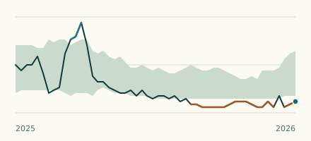 River gauge, United Kingdom Is the Alverthorpe Beck unusually low at Wakefield Henry Street Bridge? Level now, history, the same date in past years and each year's range.
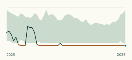 River gauge, United Kingdom Is the Balne Beck unusually low at Wakefield Brooks Bank? Level now, history, the same date in past years and each year's range.